
Humans on the twin planet
I wrote a theory about the extinction of dinosaurs and I came to the conclusion that the dinosaurs didn’t live on earth but on an another planet, a twin planet or moon that have been either captured by the gravity of earth or most probably hit by an asteroid or comet that destroyed it and pushed it to change its orbit and collide with the earth. That impact was not only the cause of the extinction of the dinosaurs but also the petrification of the dinosaurs and trees that existed on that planet. That twin planet was formed mainly of silica based rocks like Granite and Sandstones and was hit by another huge space body (probably Granite) which pushed it towards the earth. That twin planet could have been a moon. That twin planet was probably smaller and had another atmosphere and gravity. Due to the impact the planet was destroyed to pieces and was scattered on the earth, in the form of mountains and boulders.
You can read about this theory at:
http://dinosaursonthetwinplanet.tumblr.com/
I noticed that a lot of these scattered boulders are engraved with petroglyphs which are scattered on different spots on earth. I also
noticed the large scale of global violent destruction of all monolithic prehistoric structures. I noticed that the most of those structures have a kind of similarity and the most of them are of unknown origin and they don’t have much to do with the groups of people inhabiting the same area, at least from the technological point of view. I think that it's wrong to look at these structures or civilizations every one as a separate case, there must be something common connecting these civilizations. It's not just the standard or degree of that civilization but also the age they belong to with the great difficulty facing the date confirmation. I date these civilizations to the period before the Younger Dryas impact hypothesis or the Clovis comet hypothesis 12,000 and 13,000 years ago. Not finding the crater of that impact led me to the idea that the twin plant collision was what the scientists are looking for. A large scale of destruction that wiped out not only the advanced civilizations but also almost the complete human race. Some basic differences in the remains of these lost civilizations led me to the idea that the reason wasn’t a time difference but probably different human race. This collision have changed the topography and geology of the earth, which could have miss led the scientists to invent the plate tectonic theory. I found huge amount of data and information that could support my theory. I started to look for global signs that are related to such a catastrophe. This observation led me too to the idea that the twin planet could have been inhabited not only with dinosaurs but also a human form living side by side. There is a lot of evidence for this theory:
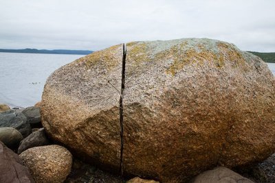
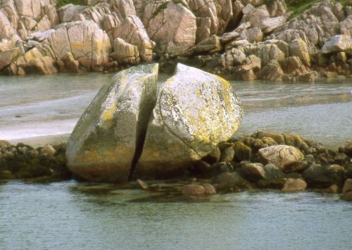
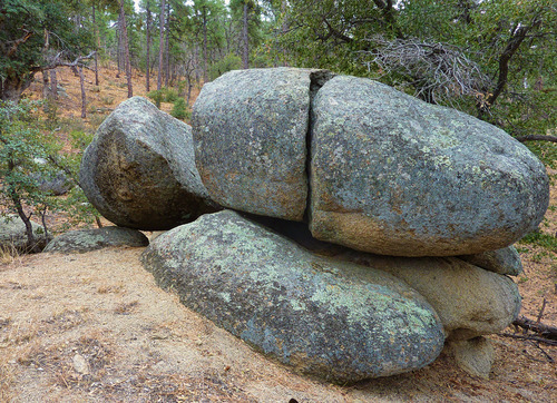
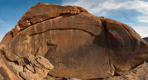
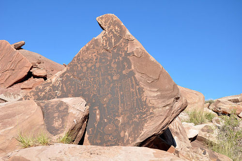
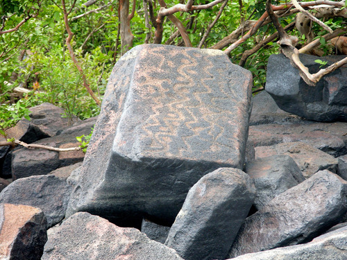
1) The most of the boulders containing the petroglyphs look like been badly damaged, you notice cracks as an indication of a distraction caused by a great force like by the impact, that damage can be seen on the most rocks in the area.
2) There are missing parts from the rocks containing the petroglyphs, that’s an indication that these petroglyphs where done before its distraction and not just done on boulders lying on the ground here and there. They were probably a part of a wall that was full with petroglyphs which stood in a vertical position.
3) The surface behind the petroglyphs have been made flat to curve the petroglyphs , the same like the petroglyphs walls of grand canyon and others, the walls where made flat before curving or painting. It’s a sign that it was a part of a bigger planed construction work or worship ceremonial place.
4) The dark red brownish patina on the stones looks rather man made than caused by erosion on the contrary it looks sometimes that the weathering affected the patina and damaged it, the same glaze can be seen on some built walls in Peru.
5) The similarity between the petroglyphs all over the world despite of the different location sometimes thousands of kilometers apart with the appearance of certain symbols in different parts of our world which indicate that they had a common origin and location.
6) The appearance of dinosaur like creatures images that lived eventually side by side with these humans.
7) The existence of some stone structures that don’t match to the geology of the surrounding rocks and suffered of great unexplained distraction.
8) These structures don’t match to the supposed time they have been erected (too sophisticated for such periods) and cause a great confusion and unsolved questions about their origin and dating some are dated to 20000 years ago and don’t match to the supposed primitive state of humans at these early ages.
9) The boulders and the stone structures have the same geological origin either granite or hard sandstone (ignitions or silica based rocks) where ever you find them.
10) The existence of the huge structures on the top of high mountains raising the question about how they have been brought to these heights, they are very remote places very hard to develop such a civilization. Such an environment is rather an obstacle for creating such civilization.
11) Lot of the blocks containing petroglyphs look like the blocks used in the Inca buildings, like Machu Pitcho and other parts in South America and Asia and even the same stones and technique.
12) The existence of petrified extinct dinosaur and tree fossils near the petroglyph places means that they are connected in some way.
13) Some consider these remains done by aliens due to the unexplained symbolism and the precision of the construction and the illogic weight of the stones which is raising the question about the kind and origin of the civilization that erected such monuments which indicate a different logic than the systematic way of thinking on earth.
14) These places have a different flora and fauna than other places, could be species that survived the impact. You find some forms of life which could be related to the dinosaurs.
15) These structures are dated between 15000 and 20000 years ago and they indicate a highly developed civilization on different parts of the world, but the evidence found from the same period indicates that the standard of the human civilization and development on earth at that age of wasn’t that sophisticated, as the remains (like tools) indicate rather primitive stage and way of living, which makes the two cultures don’t match together.
16) The ignorance of the inhabitants of these areas of the real history and origin of these structures.
17) The finding of human remains like big skulls and skeletons which could be related to other circumstances than on the earth and even the DNA is different.
18) Finding skeletons which have a different anatomy specially the sculls which are not typical for humans and mostly in Peru not far from the mysterious structures.
19) There are in almost every civilization literatures and tales about facing a great catastrophe and floods.
20) Wide range evidence of o global catastrophe that ruined a prehistoric civilization that existed on earth simultaneously.
21) Many granite boulders are showing impact signs, like being split in two parts.
I am going to explain these points using some photography and links.
Impact evidence:
All the extinction events are related to the same event and same age. The Younger Dryas event which had parallels in other parts of the earth
Did some survive the impact and left to Egypt and not the reverse way as thought?
Something dramatic happened about 12,900 years ago, and the continent of North America was never the same. A thriving culture of Paleo Americans known as the Clovis people, vanished seemingly overnight. Gone, too were most of the largest animals on the
Continent -- horses, camels lions, mammoths, mastodons, saber-toothed cats, ground sloths and giant armadillos.
Scientists have long blamed climate change for the extinctions, for it was 12,900 years ago that the planet's emergence from the to a halt,
reverting to glacial conditions for some 1,500 years, an epoch known as the Younger Dryas.
In just the last few years there has arisen a controversial scientific hypothesis to explain this chain of events, and it involves an
extraterrestrial calamity: A comet, broken into fragments, turning the sky ablaze, sending a shock wave across the landscape and scorching forests, creatures, people, and anything exposed to the heavenly fire. Now the proponents of this apocalyptic scenario say that they've found a new line of evidence: "nano diamonds." They say they've found these tiny structures across North America.
in sediments from 12,900 years ago, and they argue that the diamonds had to have been formed by a high-temperature high-pressure event, such as a cometary impact.
Geological evidence:
There is a lot of research about an impact but the problem is not finding the body. I think that a part of this body are the granite mountains and boulders every were over the globe.
Was the collision the reason for the mass extinction in America and the climate change12900 years ago?
Was the collision responsible for the ancient super volcanoes near the Utah-Nevada border?
Was the collision the cause of the ice age?
Was the collision the cause of the Chicxulub impact crater buried underneath the Yucatán Peninsula in Mexico? Was it the reason of Chicxulub mass extinction?
several other craters of around the same age as Chicxulub have been discovered
http://www.sci-news.com/geology/science-supervolcanoes-utah-nevada-01612.html
http://www.ljmu.ac.uk/NewsUpdate/viewarticle/1451/
Nano-diamonds and other exotic impact materials have been unearthed in thin sediments, Science magazine report.
The age of these materials coincides with the start of a millennium-long climate cooling event known as the Younger Dryas (named after the pollen-record of the beautiful mountain plant), - some 13,000 years ago.
Many large animals vanish from the archaeological record at this time.
It is also the period in Earth history that sees the demise of Clovis culture - the prehistoric hunters that many regard as the first human occupants of North America. Read more:
http://en.wikipedia.org/wiki/Younger_Dryas_impact_hypothesis
http://www.skepticalscience.com/news.php?n=1345
The new analysis with TEM, confirmed an abundance of diamonds in carbon spherules - melt material that forms in a fraction of a second - and the identification of lonsdaleite, or hexagonal diamonds, associated with meteorite explosions The sheer number of diamonds - up to a million times that found in neighboring sediment - and their presence inside spherules refutes the speculation that the material is the normal rain of meteorite debris, says Allen West, a retired geophysicist in Arizona and a co-author
There is no other way that hexagonal diamonds could have ended up in a carbon spherule in this number.
The absence of some traditional impact material and visible craters in North America led researchers to speculate that a meteoroid or comet disintegrated before exploding in a cluster of airbursts.
Researchers argue that the airbursts could have triggered a series of dramatic climate shifts - including colder temperatures and an abrupt change in vegetation - that would have made survival difficult for large mammals and the Clovis hunters. The cause of the disappearance of Clovis culture and mega fauna has long been and still is a debate.
Skeptics of the impact theory are not won over by the latest data. While scientists agree that something dramatic occurred on Earth 12,900 years ago, the theory that it was an exploding space rock has been cast by some as long on dramatic flair, short on
Impact theorists maintain that the diamonds peak in abundance in the impact stratum.
http://news.bbc.co.uk/2/hi/science/nature/7808171.stmthere
http://www.dailymail.co.uk/sciencetech/article-2158054/Scientists-discover-evidence-meteorite-storm-hit-Earth-13-000-years-ago-killed-prehistoric-civilisation.html
A nearly 13,000-year-old layer of sediment buried in the floor of Lake Cuitzeo in central Mexico contains an exotic assemblage of materials, including nano diamonds, that are the result of a cosmic body hitting Earth.
http://www.futurity.org/nanodiamond-dust-points-to-cosmic-collision
Research shows that a period of rapid cooling in the late Pleistocene 12,800 to 11,500 calendar years ago
http://wattsupwiththat.com/2012/06/19/the-intriguing-problem-of-the-younger-dryaswhat-does-it-mean-and-what-caused-it
The cause of these remarkably sudden climate changes has puzzled geologists and climatologists for decades and despite much effort to find the answer.
The Younger Dryas return to a cold, glacial climate was first considered to be a regional event restricted to Europe, but later studies have shown that it was a world-wide event.
Radiocarbon and cosmogenic dates of the Younger Dryas all over the world indicate the cooling was globally synchronous.
The material evidence supporting the YDB cosmic impact hypothesis spans three continents, and covers nearly one-third of the planet, from California to Western Europe, and into the Middle East. The discovery extends the range of evidence into Germany and Syria, the easternmost site yet identified in the northern hemisphere. The researchers have yet to identify a limit to the debris.
Because these three sites in North America and the Middle East are separated by 1,000 to 10,000 kilometers, there were most likely three or more major impact/airburst epicenters for the YDB impact event, likely caused by a swarm of cosmic objects that.
Such a result should support my theory about the collision.
http://wattsupwiththat.com/2012/06/13/new-evidence-of-younger-dryas-extraterrestrial-impact
another impact evidence is that the sand stone is over laying the limestone. Nubian Sandstone in Arabia
In Lebanon, Anti-Lebanon and Hermon it is underlaid by Jurassic limestone. In Western Sinai, Nubian sandstone rests on Carboniferous limestone, and by the Dead Sea on Cambrian limestone.
http://s8int.com/WordPress/2009/09/28/pteranodon-on-a-stick-egyptian-was-scepter-creature-no-mystery-without-darwinian-history
I think that the sand stone is also of an extraterestrial origin. It was one of the main components of the twin planets.
There are different collision theories
The one of Zecharia Sitchin.theory
Which says that a planet called Nibiru which had a long, elliptical orbit collided with the planet Tiamat which was located between Mars and Jupiter. The collision supposedly formed the planet Earth, the asteroid belt, and the comets. Sitchin states that when struck by one of planet Nibiru's moons, Tiamat split in two, and then on a second pass Nibiru itself struck the broken fragments and one half of Tiamat became the asteroid belt. The second half, struck again by one of Nibiru's moons, was pushed into a new orbit and became today's planet Earth.
My theory has some similarity, it says that these hypotheses happened directly to the earth. That planet or space body (Niburu) hit an earth's moon or a nearby small planet, destroyed it and forced it towards the earth.
The parts that hit the earth didn’t fall instantly on the earth but it took some time till all the parts hit the earth.
Another theory that proves unexpected cosmic events could have hit the earth once, it says that a gamma-ray burst may be the cause of an intense blast of high-energy radiation that hit the Earth in the 8th century.
http://spaceref.com/astronomy/neutron-stars/did-an-8th-century-gamma-ray-burst-irradiate-earth.html
Then we have the giant impact hypothesis states that the Moon was formed out of the debris left over from an indirect collision between the Earth and an astronomical body the size of Mars called Theia, approximately four and a half billion years ago.
It is known that Venus experienced giant impacts during its formation.
We have even the biggest debate about the Chicxulub Crater.
William F. Bottke, David Vokrouhlický, and David Nesvorný, argued that a collision in the asteroid belt 160 million years ago resulted in the Baptistina family of asteroids, the largest surviving member of which is 298 Baptistina. They proposed that the "Chicxulub asteroid" was also a member of this group. The connection between Chicxulub and Baptistina is supported by the large amount of carbonaceous material present in microscopic fragments of the impactor, suggesting the impactor was a member of a rare class of asteroids called carbonaceous chondrites, like Baptistina. According to Bottke, the Chicxulub impactor was a fragment of a much larger parent body about 170 km (110 mi) across, with the other impacting body being around 60 km (40 mi) in diameter. In 2011, new data from the Wide-field Infrared Survey Explorer revised the date of the collision which created the Baptistina family to about 80 million years ago. This makes an asteroid from this family highly improbable to be the asteroid that created the Chicxulub Crater, as typically the process of resonance and collision of an asteroid takes many tens of millions of years.
In 2010, another hypothesis was offered which implicated the newly discovered asteroid P/2010 A2, a member of the Flora family of asteroids, as a possible remnant cohort of the K/Pg impactor.
In 2013, it was suggested that the impactor may have been a comet.
The Chicxulub Crater lends support to the theory postulated by the late physicist Luis Alvarez and his son, geologist Walter Alvarez, that the extinction of numerous animal and plant groups, including dinosaurs, may have resulted from a bolide impact (the Cretaceous–Paleogene extinction event). Luis and Walter Alvarez, at the time both faculty members at the University of California, Berkeley, postulated that this enormous extinction event, which was roughly contemporaneous with the postulated date of formation for the Chicxulub crater, could have been caused by just such a large impact. This theory is now widely accepted by the scientific community. Some critics, including paleontologist Robert Bakker, argue that such an impact would have killed frogs as well as dinosaurs, yet the frogs survived the extinction event. Gerta Keller of Princeton University argues that recent core samples from Chicxulub prove the impact occurred about 300,000 years before the mass extinction, and thus could not have been the causal factor.
The main evidence of such an impact, besides the crater itself, is contained in a thin layer of clay present in the K–Pg boundary across the world. In the late 1970s, the Alvarezes and colleagues reported that it contained an abnormally high concentration of iridium. Iridium levels in this layer reached 6 parts per billion by weight or more compared to 0.4 for the Earth's crust as a whole; in comparison, meteorites can contain around 470 parts per billion of this element. It was hypothesized that the iridium was spread into the atmosphere when the impactor was vaporized and settled across the Earth's surface amongst other material thrown up by the impact, producing the layer of iridium-enriched clay.
In recent years, several other craters of around the same age as Chicxulub have been discovered. Examples include the disputed Silverpit crater in the North Sea and the Boltysh crater in Ukraine. Both are much smaller than Chicxulub, but are likely to have been caused by objects many tens of metres across striking the Earth. This has led to the hypothesis that the Chicxulub impact may have been only one of several impacts that happened nearly at the same time. Another possible crater thought to have been formed at the same time is the larger Shiva crater
, The collision of Comet Shoemaker-Levy 9 with Jupiter in 1994 demonstrated that gravitational interactions can fragment a comet, giving rise to many impacts over a period of a few days if the comet should collide with a planet.
This scenario may have occurred on Earth at the end of the Cretaceous, though Shiva and the Chicxulub craters might have been formed 300,000 years apart
Ken MacLeod, a geology professor from the University of Missouri say there was only one impact. Gerta Keller supports the Multiple-impact scenario.
There are even dating problems, some say the age of the rocks marked by the impact shows that this impact structure dates from roughly 66 million years ago. The impact associated with the crater is the reason of the extinction event, including the worldwide extinction of non-avian dinosaurs. Other researchers at the University of Glasgow dated rock and ash samples from the impact to 66,038,000 ± 11,000 years ago. Which means the Younger Dryas extinction event. I think that both were the same.
Another theory theory sayes that the Moon was created by just such a cataclysmic collision. http://www.abovetopsecret.com/forum/thread1016136/pg1 see more:
As we see there is a lot of contradiction and confusion between the scientists and their theories which makes it reasonable to take my theory in consideration.
But could be finding nano diamonds in the case of dinosaurs extinct and the Clovis people extinct could be a sign that it was the same event
Why do I think that it was a huge multi impact or collision?
First I studied the petrified remains of dinosaurs and trees and the areas surrounding these fossils and I met the conclusion that the petrifaction process couldn’t happen in the way the scientists and geologists predict, it could only happen under different physics and chemistry as explained in my theory at: http://dinosaursonthetwinplanet.tumblr.com/ .These circumstances and the nature of the dinosaurs could only be on another planet. I started to study the granite rocks and mountains and the boulders seen scattered everywhere in the world, I wasn’t satisfied with the idea that they were formed by nature and tectonic movements or stress. For me they look more like a part of another planet or moon that collided with the earth (not only an asteroid which hit the earth somewhere) and it must have caused great global damage and changes much bigger than the impact crater of Yucatan. This impact or collision made great changes on earth, it reshaped the planet. It could have caused the movement of the so called continental plates and formed new continents. Parts of the Americas, Asia and Australia and other parts are formed mainly from parts of that destroyed planet. The added rock mass caused once the expansion of the earth crust and continental drift. Large areas of the old earth are under the rubble and debris. Large once dense inhabited areas are buried under parts of the destroyed (exploded) twin planet. (could this be the origin of petroleum?). The basin of Mexico was once dense populated now we have a lot of petroleum there. Are the coal mines a result of that event? The uplifting of the earth crust in some parts is the explanation for finding mammoth remains more than two thousand meters above sea level, an altitude not usually frequented by the mammoth species. Researchers are wondering if the animal had strayed beyond its natural habitat. My explanation is that the area was originally lower as they lived there but the area was uplifted due to the impact. I think that the collision was the cause of the ice age. It was also the cause of lots of volcanic eruptions, fault lines and earth quakes. It is the reason for the polar wander and the formation of mountains.
Read more: http://digitaljournal.com/article/348182#ixzz32KjZk7Bb
The distances were smaller, parts of the earth have been separated, which makes it difficult to explain the human race migration for such large distances, but actually these distances occurred after the collision. The added mass increased the earth radius and mass.
The added rocky mass to the earth caused the rise of water in the oceans. Shallow parts of the ocean were dry, that could be the explanation for finding human remains and extinct species in the underwater caves in Yucatan in Mexico. Such caves have been above sea level before the collision.
http://www.bbc.co.uk/news/world-latin-america-16632419 Read more:
http://www.abc.net.au/news/2014-05-16/13000-year-old-skeleton-found-in-mexican-cave/5456472
http://www.ctvnews.ca/sci-tech/pristine-prehistoric-skeleton-of-teenage-girl-found-in-underwater-cave-1.1824386
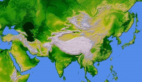
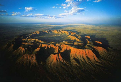
The Granite Mountains in the Americas, the Rockies and the Andes mountains or the Huangshan (yellow mountains) in southern Anhuni province in eastern China or the Brandberg Mountain in Namibia and the Altay Mountains in Central Asia which extends 1200 miles (2000 km) in the southeast-northwest direction from the Gobi (desert) to the west Siberian Plain through where China, Mongolia, Russia and Kazakhstan, all belong to the twin planet.
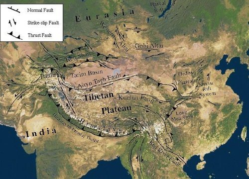
I think that the 2,500,000 square kilometers Tibetan Plateau is the largest body that hit the Earth and caused the most expansion of the Earth crust. It pushed the Himalayan range
It is thought that the Siberian Altai is the northernmost region thought to be affected or formed by the tectonic collision of India into Asia. Massive fault systems run through the area, including the Kurai fault zone and the recently identified Tashanta fault zone, its thought that they are strike-slip faults, some of which contain tectonically active Rock types like Granite and Metamorphic Schists mountains.
But what I think is that all the silica based mountains like granite belonged to the twin planet and the body that hit it and these mountains were not formed by tectonic movement or stress of the continental plates but they were a parts of the damaged or exploded planet which collided with the earth and caused radical and violent changes to the earths geology and topography, it led to the almost total extinction of humans.
The question about the formation of the mountains led the scientists to search for the reason and after exhausting attempts the conclusion was the plate tectonic theory, which became in spite of some debatable issues the accepted theory of the mainline geology. My theory does not agree completely with this theory.
My theory depends on the same facts like the plate tectonics theory. Continental drift, seafloor spreading, Earthquakes, volcanic activity mountain-building, paleomagnetism, seismicity zones and oceanic trench formation which occur along these plate boundaries. The continental lithosphere is lithosphere is thicker than the oceanic, and the continental crust is being considerably thicker than oceanic (35 km vs. 6 km). There is some similarity with mars. The hemisphere south of the dichotomy boundary on mars (often called the southern highlands or uplands) is very heavily cratered and ancient, characterized by rugged surfaces that date back to the period of heavy bombardment. In contrast, the lowlands north of the dichotomy boundary have few large craters, are very smooth and flat.
The matching of the rock formations and the fossils along these edges between South America's east coast and Africa's west coast is a confirmation of their previous contiguous nature.
Mountains formation
There are actually several theories about how mountains are formed, and they all have to do with processes that take millions of years.
Read more:
http://www.universetoday.com/29833/how-mountains-are-formed/#ixzz2luwTAkf
The imaginary theory of the scientists is convinced that many of the major mountain ranges are created when the Earth’s tectonic plates crash together. Mountains form because of movement in the earth's crust when the earth's tectonic plates move together or grind against each other this can result in a mountain range forming. Because of the tremendous energies involved, the sides of the plates crumple like cars in a head-on collision. The mountain ranges are created because of those crumpling plates. The Indian subcontinent “crashed” into Asia 25 million years ago and created the Himalayan mountain range.it is thought that the Himalayas are still growing.
The next way that mountains are formed is along fault lines. Blocks of Earth are uplifted and tilted over as two plates grind together. The uplifted part forms a mountain, and the lowered parts are filled in with eroded material. An example of this is the Sierra Nevada mountain range in California.
Another way that mountains are formed is when magma from beneath the Earth’s surface is pushed up, but doesn’t actually crack through. This bulge of magma eventually cools and hardens into hard rock, like granite. The layers of softer rock above the magma erode away and you’re left with a large dome-shaped mountain.
The final way to form a mountain is through erosion. If you have a high plateau, rivers will carve deep channels into the area. Eventually, you have mountains in between the river valleys.
Tectonics geologists recognize that movements in the earth's crust such as those that formed the Himalayas, have created most of the major mountain belts in the world. According to the theory of plate tectonics, the earth's crust is made up of about a dozen large rigid plates that move a few centimeters per year independently. A collision between plate triggers deformation and thickness of the crust, which leads to crustal uplift and mountain formation. A common process produced by horizontal compression is the deformation of layers into folds or wrinkles. The Himalayas, for example, rose as a result of the compression and deformation that accompanied the collision of the Indo-Australian plate with the Eurasian plate. Compression generated by the collision of the African plate formed Europa's Alps and the Jura mountains in France.
Continents according to the theory of the tectonic effect didn’t form because of floating on the top of the oceans but as the earth crust is floating on the hot liquid core. That means that mars and mercury which had once a hot core too, as we see the volcanoes on them, must have had tectonic movements too, but they hadn’t. Therefore I think that the Granite Mountains are not part of the original Earth, and they didn’t form due to plate tectonics but they are parts of the twin planet that collided with the earth. When the huge parts of the planet hit the earth they caused uplifting of parts of the earth crust which formed the lime stone mountains, like the Alps. The earth should have impact craters like mercury and mars or even more as its gravity is bigger than both. Where are these craters? They are covered by parts of the twin planet which changed the original topography of the earth. There other planets didn’t experience such a dramatic impact like the earth. Another thing is that Mars and Mercury don’t have active volcanoes any more, its cores cooled down. Then why is the earth's core still hot? Most probably the earth cooled down too, but the impact brought its core to the melting situation once again due to the energy generated by the strong impact, which caused new Geological changes like tectonic effects, volcanoes and lava flows and fault lines.
My reasons to reject the plate tectonics theory:
There is a kind of naïve imagination about some parts of the theory like:
*The prediction of plate tectonics is also referred to as the conveyor belt principle.
*The Earth's crust is made of a jigsaw puzzle of continental and oceanic plates that are constantly ramming each other, sliding past each other, or pulling apart.
*Along the Ring of Fire girding the Pacific Ocean, for example, the seafloor plunges beneath Asia and the Americas, building mountains, feeding volcanoes, and triggering earthquakes.
*Plate tectonics in which huge crustal plates pull apart, smash together and dive under one another exist nowhere in our solar system but Earth.
See more at:
http://www.space.com/17087-mars-surface-marsquakes-plate-tectonics.html#sthash.8R7zMq97.dpuf
I think that this theory gives the impression that the continents and plates are floating on the oceans and move so easy that they crush together, but the plates and continents are a part of a thick and solid crust. In case of such a movement that means that the whole crust would move and this movement was thousands of kilometers and if the formation of the mountains had anything to do with this movement there should be a relation between the distance the continents moved and the height of the new formed mountains, it means they should be much higher.
The Earth might have a liquid core and a solid crust and mantle, but I don't think that portions or layers of the crust could move around freely separating itself from the felsic part above it forming a kind of floating continents.
It is thought that continental plates are moving very slow, a process that takes tens of millions of years to form mountains. But when we look at these mountains and uplifted layers they look more like have been formed very fast and violent, which can happen only through an impact. Like in the case of coal mines, it doesn’t look like taking millions of years to be buried it happened in a very short time and in a sudden way. If it would have taken a long period the trees would have changed their position.
We may have magnetic anomalies and different pleomagnetism. It is thought that certain minerals in rocks lock-in a record of the direction and intensity of the magnetic field when they form. This record provides information on the past behavior of Earth's magnetic field. That would be because the rocks belong to different planets and there have been a polar shift but the collision was the reason, it caused changes in rock magnetism belonging to different planets. The collision caused a kind of polar shift but this was not a normal behavior of the earth. A powerful impact and the change of the earth's mass could have such an impact.
Distinguished scientists, such as Harold Jeffreys and Charles Schuchert, were outspoken critics of continental drift.
The driving forces for the plate tectonics are still a subject of debate. I am convinced that the collision and the impact force is actually the real driving force for the continental drift and not an earth self-generated deep under earth crust driving force. I don’t agree with the floating continent theory. The huge added matter (the impact body or planet) caused the expansion of the earth crust and the continental drift.
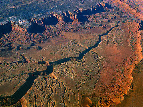
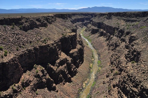
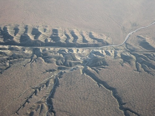
You can see on the maps of the Americas, the dark parts or mountains to the west must be a part of the impact of the destroyed twin planet and fall on earth. Interestingly near these mountains you find mostly dinosaur remains and also the remains of unexplained lost civilizations at the same time. The Granite mountains don’t look like have been formed by tectonic pressure. There are other miss explained geological formations. The main stream consider that that the Grand Canyon and other canyons were formed by flood waters but I would rather think that they are cracks in the earth crust caused by the impact, by the expansion of the earth crust. The bottom of the canyons don’t look like have been washed away as you see small hills inside the canyons that have not been washed away and the rough sharp rocks don’t look like been shaped by water. That will depress some scientists which are relating the idea of the existence of water on mars with discovering of canyons. These canyons are probably formed by the expansion of the crust of Mars too. I can notice four different expansion layers, which means that there was probably four major impacts.
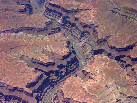
The Grand Canyon above looks more like a crack or fracture rather than caused by flood water as the valley above it is wide enough to contain any floods. (the surface above the canyon is flat and wide enough to allow floods to move freely and smoothly).
You notice small canyons leading to the deep canyon, they are created by flood water and leading to the bigger canyon. They show the amount of water flowing into the canyon, the effect is not that great to cause such a deep canyon, there isn’t a real relation between both of them. I think that the water just flow in to the existing canyon. We notice that there are different layers or canyons, a very wide one on the top and a smaller one beneath. This could be an indication that there was two or more different impacts, a major one and another secondary impacts. I think that a simple calculation would give use a real imagination about the total size of earth crust expansion which would tell us the size of the planet before the collision.
Next you see the Vermillion Cliffs in Arizona. You see that it looks more like a crack in the earth crust. Parts of the upper soil on the to fall to
In the north of Canada on Davon island is the Haughton impact crater shown on the radar image below. You see the cracks caused by the impact and the similarity with the Grand Canyon. You notice the relatively flat surface, the status the earth crust should have looked like before the impact. You notice the splitting of the earth crust due to the expansion after the impact: 75°51'36.01"N90°57'25.57"W W73°36'51.09"N94°13'4.24"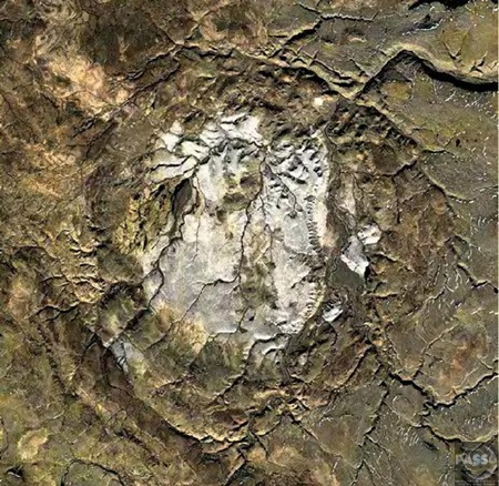
Below we see in Norway cracked earth crust.
Below for comparison is the San Andreas Fault which is a fracture or a crack in the earth crust, there is a similarity with the Grand Canyon which means that the Grand Canyon was formed in the same way.
The whole area around the mountain could be a part of the twin plant that landed or fall on the round surface of the earth and took its round shape which caused the crack in such a form. The upper layer of Sand Stone lays over the original Limestone bottom surface. Another possibility is that the huge parts of the twin planet when falling on the surface of the Earth caused such cracks. It could happen also due to the expansion of the earth crust.
Some scientists talk about great Unconformity of the Grand Canyon.
Read: http://written-in-stone-seen-through-my-lens.blogspot.com/2012/01/great-unconformity-of-grand-canyon-part.html
Above is the San Andreas Fault you notice the same cracks like the Grand Canyon.
Below you see the different types of rock meet along the San Andreas Fault. I think that the dark one to the right is of the impact bodies (granite or sand stone) and to the left is the original earth limestone crust. You notice the impact power uplifting the crust.
On the moon we have fault lines; they emerged as the moon is shrinking. The cooling has reduced the radius of the Moon by around 100m in the relatively recent lunar past, evidence indicates. Which means that there have been geological events similar to those on earth but without plate tectonics.
I even think that the earth was in great danger as its core was cooling and the live was threatened but this impact caused a new heating of the earth inside by melting the core as a result. We must realize that all planets are cooling by time, the same happened to mars which was warmer and living but the cooling ended any life possibility. We have enough evidence now that there was in the past lots of volcanoes on Mars but now no more.
The collision may have added even water as the other planet had water too.
Fault systems are in the Himalayas and Tibet, and in California not far from granite mountain and not far from the ring of fire.
I think that the heavy Granite Mountains are causing earthquakes and volcanoes as they slide and bush deeper into the earth and that effect makes us think that it's the tectonic pressure or force. There is even the possibility that the twin planet was hit by a large granite space body but didn’t destroy it but it was nailed into it. The weight and pressure of that body caused volcanoes and earthquakes and cracks as it kept on pushing into the depths of that planet and caused the expansion of the crust till it exploded. Which means that the earthquakes and volcanoes could be caused by a similar pressure.
http://www.telegraph.co.uk/science/space/7954686/Surface-cracks-show-the-Moon-is-shrinking.html
Fault systems and the ring of fire are around the Himalayas and Tibet and California not far from the Granite Mountains, which according to my theory are pushing downwards and cause such formations.
Mars has the longest and deepest canyon system anywhere in the solar system. Valles Marineris extends for nearly 2,500 miles (4,000 kilometers), making it about nine times longer than Earth's Grand Canyon. But the reason was not flood waters once existed on that plant. It was probably the large meteorite impacts that hit the planet.
Is not an evidence for Martian plate tectonics. it is just a big crack. Mars has almost no thermal energy any more. We shouldn’t take fault lines as an explanation or reason for plate tectonics.
See Mars surface video:
http://www.youtube.com/watch?v=crsqzZNUXsY#t=203
http://www.youtube.com/watch?v=U5pnfpRiwi8
the granite mountains for me don’t look like been formed by tectonic pressure. According to the tectonic theory the movement was very slow it took millions of years to form, but the sharp edges of the Granite mountains look more like been formed very fast and violent, they look more like broken parts of a planet. According to my theory if the continents have moved thousands of kilometers which mean that there must be a relation or mathematical pattern between the height of the mountains and the distance that the continents or plates moved.
If Granite was pushed from the bottom to the top or uplifted, we would find uplifted parts of the surrounding rocks with the Granite. It's always pretended that such rocks have eroded away, but there can't be a total vanishing as predicted. The granite itself would have protected large parts of these rocks. It's also hard to imagine that weaker rocks and smaller in mass are able to push harder mass like granite to such heights.
If the continental plates movement caused the mountains to rise till they reached such heights, that means that the movement was converted from a horizontal movement to 90 a degrees vertical movement and on the same spot. Which means that the horizontal movement stopped? If the plate did keep pushing the mountain wouldn’t that change the angle of the mountain and cause it to collapse? If the plate is continuing to move it would form smaller mountains in parallel lines.
The continental plated haven’t been physically detected till now.
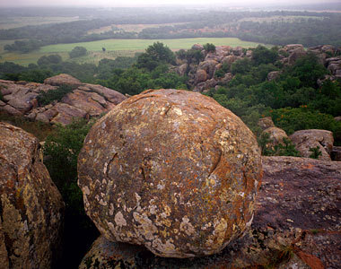
The granite mountains look very young, no great signs of erosion that should happen in millions of years, if they were really so old. They must be much younger on Earth than thought. The collision was probably in the last few hundreds of thousands years and not millions of years ago.
We don’t find granite boulders in the rock strata but just near the surface, which means it's not an ongoing process but just related to a certain date.
Above is the Clach Bharraig is a large boulder perched on the hillside above the road to the car park at the Cairngorm ski area.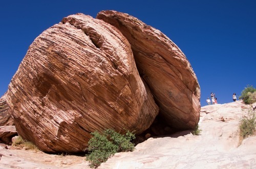
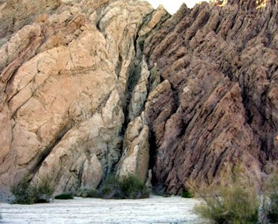
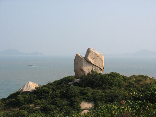
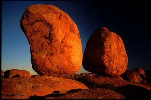
Above is the Las Vegas, Red Rock Canyon split Rock. Only an impact could cause such a split.
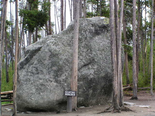
Below two images of huge boulders from the Yellowstone National Park in the state of Wyoming U.S. You see that the first one has a crack.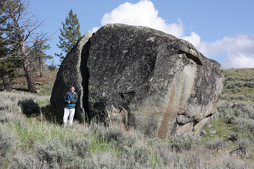
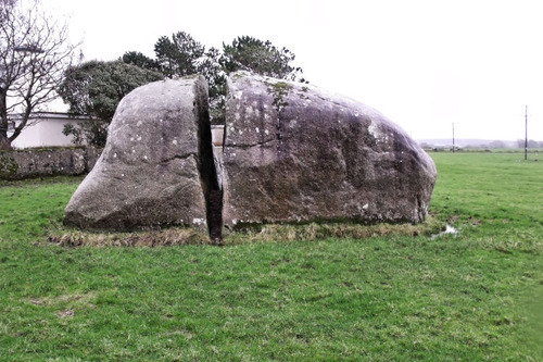
Below a is huge boulder in New England on the south shore is split all the way through.
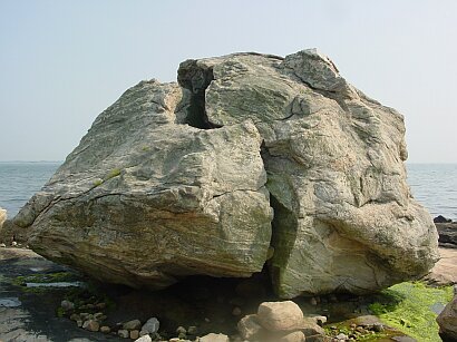
The next image is a split rock in Newman Sound in Canada. Thought to be a Glacial Erratic but it wouldn’t cause such a crack.
Above is the Nose Creek Pathway Erratic in Calgary West Nose Creek Park, also known as Confluence Park Canada.
Below is another cracked granite boulder in Scotland Ffionphort.
Below another split rock at Mount Woodson area in the northeast corner of the city of Poway north of San Diego and just south of Ramona. Here another evidence for a crack that could only be caused by an impact.
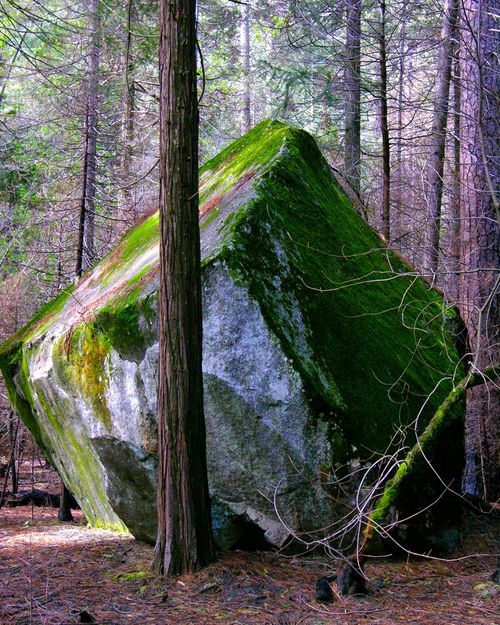
The next image is the Tilden canyon shattered rock at Yosemite National Park. Such a damage can only be done by an impact.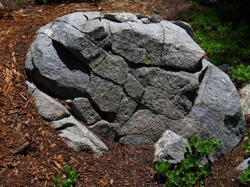
Below the granite split boulder and sits on top of Steamboat Rock in Washington.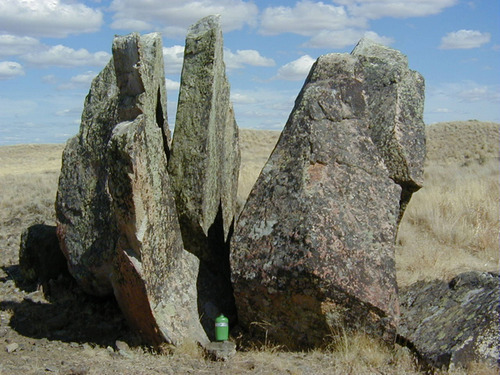
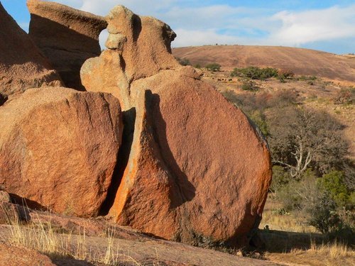
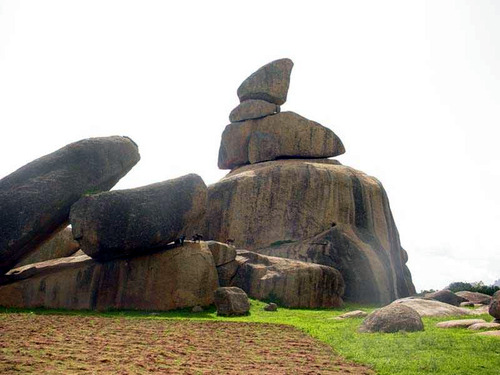
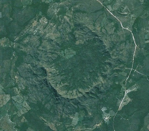
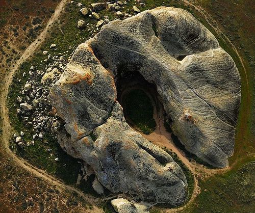
The Enchanted Rock or the Llano Uplift seen below 15 miles north of Fredricksburg in central Texas is a roughly circular geological Granite rock (considered as a Precambrian rock) rises 122 m. above the surrounding landscape surrounded by boulders an evidence of the impact and fallen rocks.
The rocks are even on the top of the dome, another indication that it fall on it. Such scattered boulders are everywhere not far from the Granite mountains. They could have got their shape when entering the earth atmosphere. You can notice that the upper part was separated as an egg shell according to the heat when entering the earth atmosphere and the collision with the earth.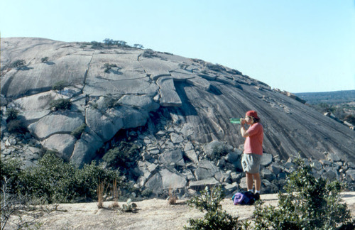
As you see below the boulder broke as a result of the impact.

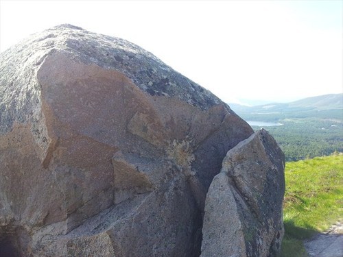
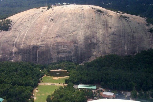
Below you see the Stone Mountain in Atlanta is a mysterious rock almost round and solid piece of granite. On the top of it are marks like carvings could be man made not by ice as mostly thought.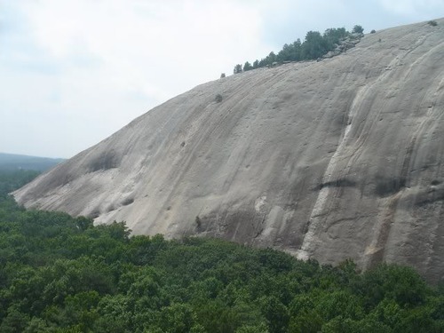
Below a similar stone mountain in Georgia.
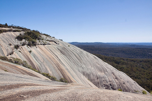
Below is Australia's largest exposed granite rock Bald Rock is and second largest rock in Australia and is the main feature of the Park. This magnificent dome is 750m long and 500m wide.
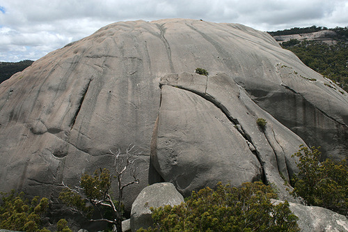
Below in australia queensland girraween. The granite at Girraween is just one small section of a great mass of rock - the Stanthorpe Granite - which underlies most of the Granite Belt of Queensland part of the New England Batholith - which stretches from just south of Warwick (in Queensland) down to Armidale (in New South Wales); a distance of just over 250 kilometres (160 miles). You notice the similarity with the Llano Uplift above.
The next image from Australia the Granite Arch in Girraween National Park.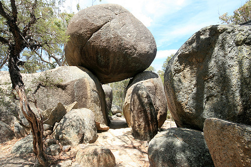
The next image from New Zealand, the Punakitere Sandstone boulder.
Above is a Granite dome at the Yosemite national park in California.
The photo below shows one of many huge boulders thought to have fallen off the Yosemite dome. This can happen just in case that the Yosemite dome itself fall on the earth and parts broke off due to the impact.

Above is the Old Woman rock formation (Joshua Tree National Park)
Below is a cracked boulder in the Bradshaw Mountains in central Arizona.
Below in Hon Kong the stone pillar of the village, Shek Shun Cheun, the great menhir Island Fan Lau.
Below is the summit of Crungie Clach near Pitlochry, Perth and Kinross, United Kingdom (619m), thought to be a granite erratic but the ice would move it down the hill and not to the top.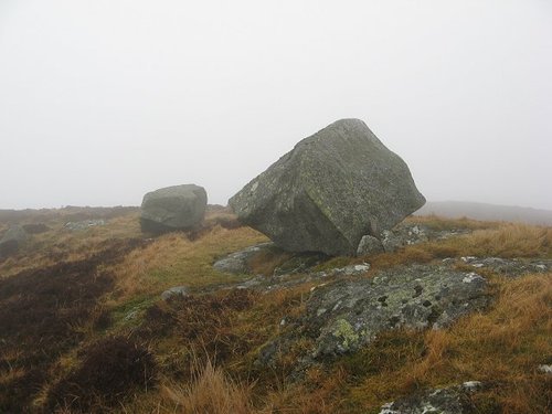
Below is the Split Rock, located just outside the village of Easkey is a large glacial erraticin County Sligo, Ireland.
Below is the Riyom rocks in Nigeria huge granite boulders and the whole area is covered with granite inselbergs.
Below in Nigeria the Amoye Inselbergs (Olosonta Hill) - in Ikere Ekiti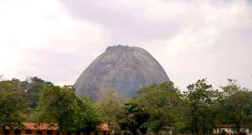
Below is another granite dome in India Lyngam- West Khasi Hills.

Above is the Corcovado Mountain in Rio de Janeiro, Brazil.
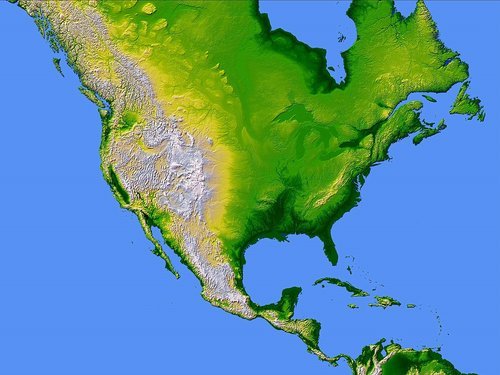
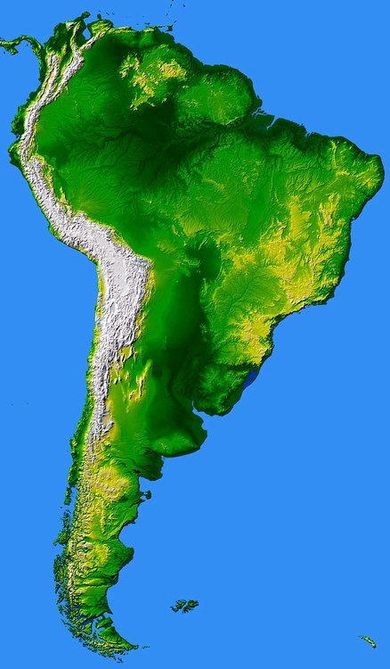
Above are the maps of North and South America, you notice the granite mountains to the west and below the map of Asia showing the Granite mountains in central Asia. These are the biggest parts that hit the earth (main impact bodies) which caused the expansion of the earth crust. But there are other smaller parts that hit different parts of the globe. some islands have been formed of such extraterrestrial rocks.
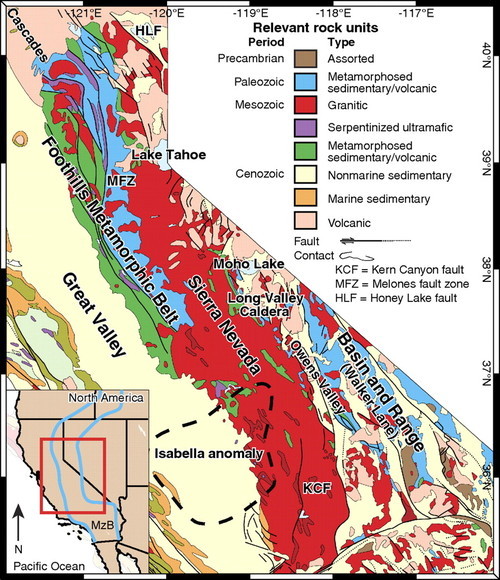
Below is a map showing the Structure of the Sierra Nevada.
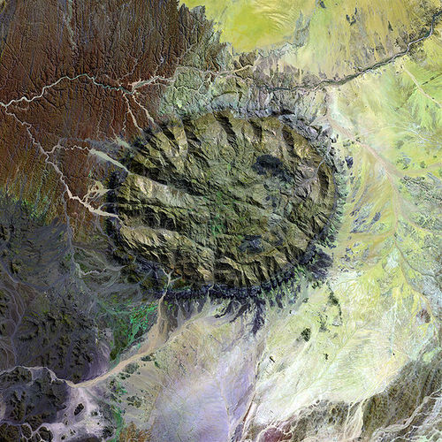
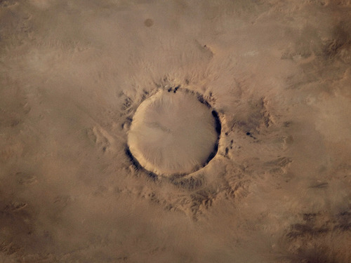
Above is a satellite image of the Brandberg Granite Mountain in Namibia clearly seen the dark circle around the mountain caused by the heat of the impact. You notice as well the two dark spots to the right were magma or lava came of it from inside the earth after the impact.
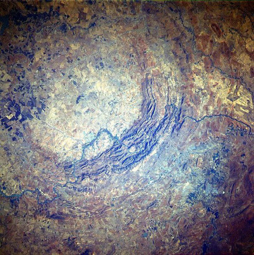
Another evidence for the impact is the Verdefort crater in the Transvall Basin in South Africa, seen in the image below, the largest impact crater on Earth almost 300 km in diameter. It consists of a granite dome 40 km in diameter in the center of the crater. Then we have different kinds of rocks forming rings round the crater center like an arc of Ventersdorp lavas formed by the lava flowing out of Earth after the impact and then we have the outer rings formed mainly by Ghaap Dolomite rocks a form of carbonate mineral like Limestone which belongs to the original Earth before the impact. We find high content of iridium in the area which is mostly found in meteorites . We find also platinum what I think that it has extraterrestrial origin and wasn’t formed on Earth, the same could be the case with gold and the whole platinum-group metals.
Also the Tswaing crater below in South Africa is a smaller one (1.15 km diameter) it has enough granite remains to be a prove that this meteorite was composed from granite. It's also an evidence for the existence of stony meteorites impacts and not only iron meteorites. The surrounding area known as the Bushveld complex is one of the important sources of the platinum group metals. The crate floor is covered with a high concentrated saline lake, what could be an indication that the salt on earth could have an extraterrestrial origin.

http://www.lpi.usra.edu/science/kring/epo_web/impact_cratering/enviropages/Tswaing/Tswainggeologypage.htm
Below is the Araguainha crater in Brazil which has a granite central core.
The Tenoumer crater in the western Sahara is another evidence for the abundance of granite in impact craters.
The Atacama crater in northern Chile South America has a granite.
bedrock. The granite inside the crater reveales a reverse magnetic field
Polarity. The issue of reverse polarity is noticed mainly in Granite and not Basalt.
The outside rim of the Pingualuit Meteorite Crater is covered with a jumbled heap of large fragments of granite blocks. These could be remains of the impact body that was destroyed. The melt rocks are recognized as a mix of granitic gneisses rocks.
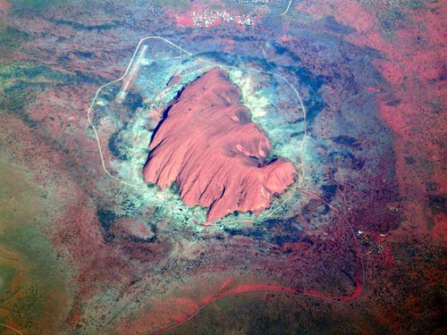
Below is the Ayers Rock or Red Rock, in the Ayers Rock in Uluru National Park in Australia, you notice the dark circle around the mountain caused by the heat of the impact. The Uluru rises to a height of about 340 metres (1,114 feet) above the desert plain, its summit 867 metres (2,845 feet) above sea level. An isolated sand stone rock-mass, it measures nine kilometres (5.6 miles) around its base. It consists of many layers, it looks like been uplifted standing almost vertical (dipping at 80–85°).
Not far from the Ayers Rock you find the Kata Tjuta rock. Kata Tjuta is about 30 kilometres (18 miles) west of Uluru, consists of a series of huge, rounded rocky domes as seen below. It reaches 1069 metres (3,507 feet) above sea level and about 600 metres (1,970 feet) above the desert floor. these spectacular domed rock-masses cover an area of about eight kilometres (five miles) by five kilometres (three miles). The rock layers here only dip at angles of 10–18° to the southwest,
35 kilometres (22 miles) north-west of Kata Tjuta you find pebbles, cobbles, and boulders of other rocks and consist mainly of granite and basalt, but some sandstone, rhyolite (a volcanic rock), and several kinds of metamorphic rocks are also present.
Below from the same area you see the boulders that fall on the domes.
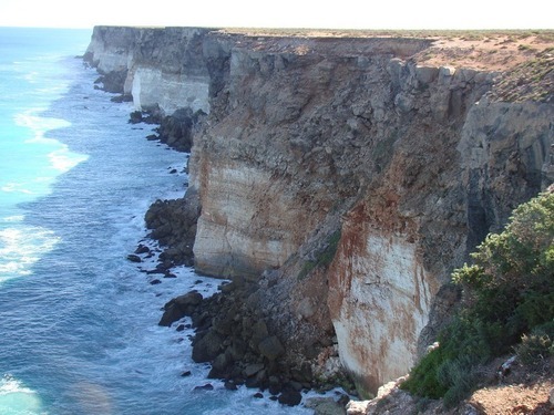
See more: http://www.amusingplanet.com/2013/05/bunda-cliffs-in-australia-is-this-end.html
Above is the so called painted rock which seems not to belong to the area, underneath is a kind of cave with old paintings and symbols of unknown origin. You can notice that some rocks broke apart after the impact and they lay nearby.
I imagine that the twin planet was a smaller planet, had a lower gravity and was inhabited by different species, like dinosaurs and a kind of human race and huge trees as well. After being hit and destroyed to smaller parts it moved towards the earth and was captured by the earth gravity until the collided together. The dinosaurs and the bigger trees went extinct and some remains petrified. Some of the smaller species survived. Could this be possible? The scenario could be as follows: The impact pushed the planet towards the earth it didn’t have the same speed like asteroids as it didn’t travel a long distance in space, it depended on the earth gravity, the bigger parts took probably a spiral orbit and landed on different parts on earth which were covered by bigger oceans, smaller parts fall in the form of boulders with higher speed and bombarded many parts on earth. The theory of the Yucatan impact crater could be real, but it was only one of many others. The middle size parts formed smaller mountains and islands.
But what could have happened to the twin planet if it was inhabited?
Did the inhabitants of the twin planet know that a cosmic catastrophe is on the way?
Was the destruction of the planet caused by an impact or a disaster caused by the inhabitants themselves? Did it collide with the earth due to the gravity of the earth (being captured by earth gravity)? Was it hit by an asteroid or its own moon that destroyed it and pushed it towards the earth? Was it another moon?
Did the inhabitants of the earth notice that a planet left its course and is moving towards them? Did the inhabitants of the twin planet build structures to protect them when entering the earth atmosphere? I think we would have done it.
The twin planet could have been a moon that circled the earth. Which means that the collision wasn’t the destructive like being hit by a fast moving body like an asteroid or a meteorite. The twin planet could have been hit by a moving space body that crashed it and bushed it towards the earth.
Stories about Atlantis and aliens visiting the earth:
https://bruceleeeowe.wordpress.com/category/conspiracy
http://www.virtuescience.com/grooved-spheres.html
http://davidpratt.info/andes1.htm
Evidence of extraterrestrial civilization on the twin planet:
Petroglyphs, Monolithic structures, Dolmens, Menhirs and strange looking features
We notice the kind of metallic patina or coating of the petroglyph rocks and also in the megalithic structures in Peru. There is a similarity between them. They are not a result of erosion.
A scientist that did detect a kind of vitrification was late prof. Watkins. He said that the rock surfaces on Inca stones are similar to those that have been thermally disaggregated. Indeed, some of the slick surfaces on the Inca building stones are glazed, so it becomes apparent that the Incas must have used thermal disaggregation..
http://blog.world-mysteries.com/science/evidence-of-vitrified-stonework-in-the-inca-vestiges-of-peru
http://www.pbase.com/manco/image/21583800
Evidence of Vitrified Stonework in the Inca Vestiges of Peru.
http://www.ancient-mysteries-explained.com/support-files/evidence_of_vitrified_stonework_in_the_inca_vestiges_of_peru.pdf
http://secretsofthesunsects.wordpress.com/2011/12/05/incan-vitrified-stones
http://www.grahamhancock.com/forum/JongJP1.php
Alfredo Gamarra's investigations and theory are based. He came to the conclusion that the 3 different styles we recognize in all the vestiges, correspond to three different periods of human history. The first style is holy for the two later styles. The vestiges of the first and second period show phenomena that till now where not explained in an acceptable way. Alfredo Gamarra said that, because of less gravity in the past, it was possible to handle huge blocks of stone, treat stone with moulds, and give them a vitrified finish. Those stones must have been soft once. But Alfredo Gamarra said that the perfect fitting blocks do so because they were moldable on the moment of construction. If Alfredo was right, one can imagine that especially bigger blocks were more difficult to treat, as the weight of the clay-like block would have given problems to keep them in place, and the clay could have had the tendency to deform. The clamps would have served for keeping the blocks together, so they would harden out in the right position. The observation that the groove has been polished is important here. The same can be observed on the borders of the stones of the perfect fitting walls. Some technology with heat was applied to give form and strength to the construction. This means the shine is not because of polishing, but would be vitrification. The relatively big presence of the first style in Cusco and surroundings, leads to the conclusion that this part of the world was important during the first period, and could be considered as the cradle of Humanity
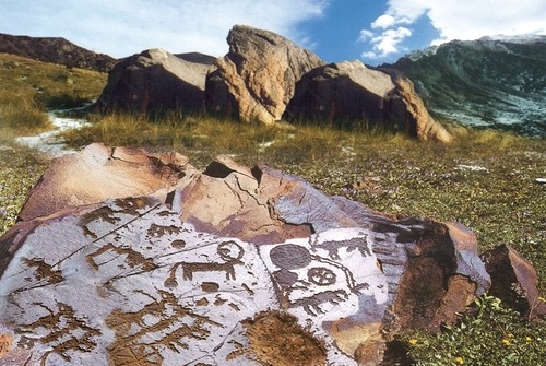
1) petroglyphs:
I think that the petroglyphs have been done on those boulders or rocks before its destruction probably on the twin planet. The power of the impact was so strong that lots of these hard rocks (mostly Granite or hard sandstones) have suffered such a damage, as the cracks are seen on the most blocks. We notice that many petroglyph sites are not far from areas where petrified trees and
dinosaurs. Which made me think that there could be a connection between them. What caused the destruction of the rocks containing the petroglyphs and also the extinctions of the human race related to them could be the same reason of the extinction and petrification of the dinosaurs.
The petroglyphs are made on a flat surface which is clear that it was man made flat surface as we can notice the marks of some kind of tool. I am going to show you some photos were you can see the broken stones with missing parts of the petroglyphs and also the flat surface which wasn’t done by nature.
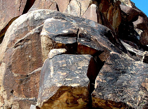
You find these rocks in places you don’t expect to find them, or you ask your self when you see them who brought them here.
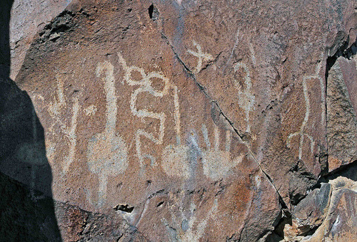
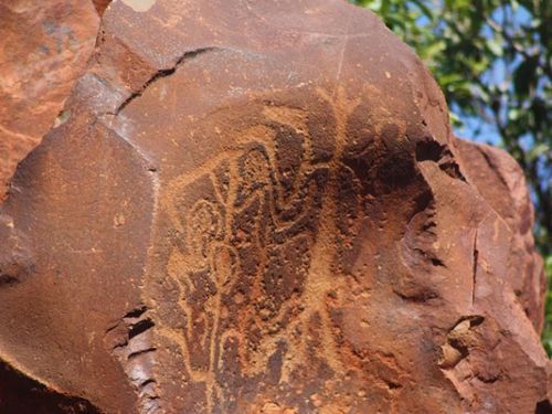
You are going to notice all of them have the brown patina and all of them suffered a great damage and you feel that they are just a part of a bigger wall or structure which was full with such symbols. These engraved rocks are mostly found in total remote places where its hard to imagine that these places were once inhabited. And if you find some tribes that lived around you notice that there isn’t a real connection to the petroglyphs. These petroglyphs show a kind of stone masonry that these tribes didn’t possess. These rocks don’t look been accidently decorated by a passing byer. All over the world they are scattered and destroyed.
One of America's most interesting national parks is located in northeastern Arizona not far from the more well-known Grand Canyon. The 93,533 acres of Petrified Forest which contain America's largest deposits of petrified wood, a rich and colorful desert, many fossils of dinosaurs and other creatures, and more than 500 archaeological sites including amazing petroglyphs left by ancient cultures
http://www.shannontech.com/ParkVision/PetForest/PetForest.html
Above is the Greaser Petroglyph Site in Oregon
Above the so called Apache spirits southeastern Arizona and north-western Mexico, you notice the cracks the flat surface and the patina.
The patina could have been caused by the heat of the impact or the effect of the atmosphere on the twin planet.
Below a petroglyph from the Anasazi Valley. Looks like belonging to a bigger scene.

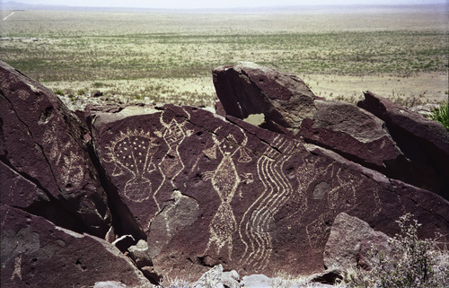
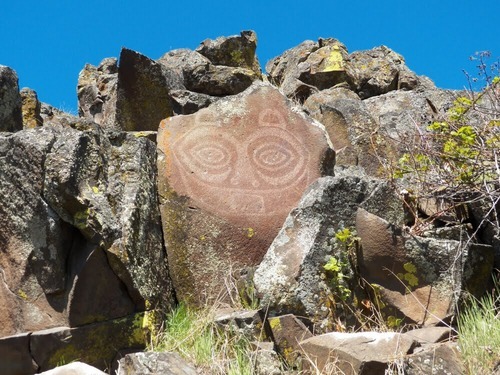
Above the so called Coso Shaman human like figures overlooking the Renegade Canyon on the China Lake CA.
The next petroglyph shows clearly the man made flat surface and the distraction of a bigger stone complex a kind of sacred mountain in Columbia Hills State Park. You notice to the top left a rock that appears to be a corner of a chamber.
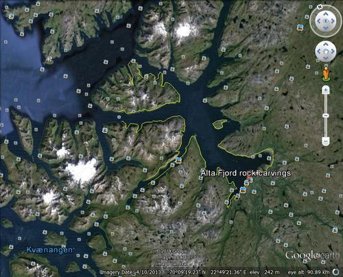
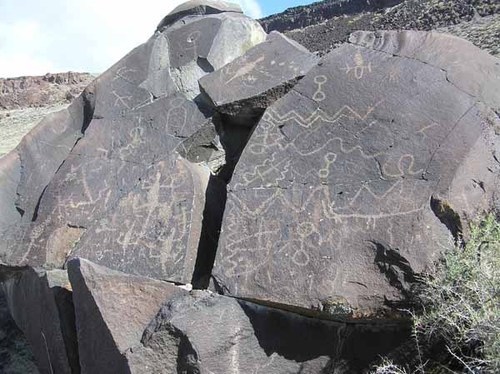
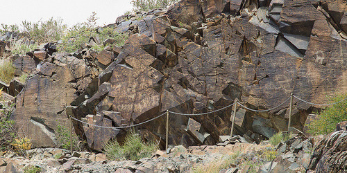
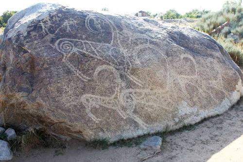
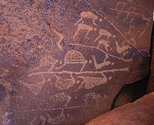
Tamgaly is a World Heritage Sites in Kazakhstan one of the World Heritage Sites in Northern and Central Asia.
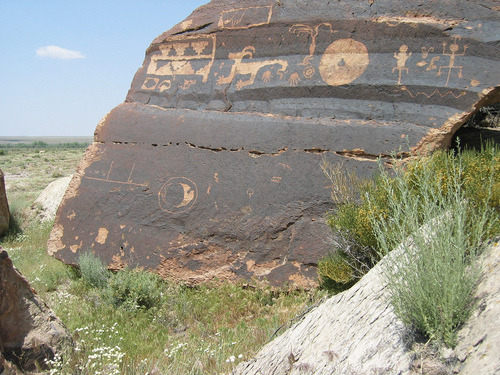
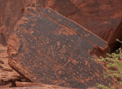
See the scale of destruction of the granite mountain; you see that the damage was after creating the petroglyphs. Another thing what you can see clearly is that the flat surface have been worked out by a tool, you can see clearly the marks of the tool. Another thing is the patina, it looks like glaze or painted. The lower part has been affected by rain or floods. The scenes are very similar to other places like the Americas or Australia.
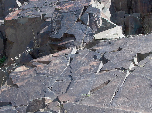
Above is a Tamgaly petroglyphs in Kazakhstan notice the man made flat surface. The animals some could be dinosaurs. Notice the damage done by the impact. You can watch this site in this video: http://www.youtube.com/watch?v=tcWFwh0fBN4You
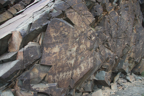
Above is the Tamgaly petroglyphs from the Semirechie region in Kazakhestan.
Above From tamgaly petroglyphs Kazakhstan clear evidence that the petroglyphs have been a part of a mountain and not some scattered boulders.
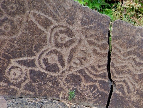
A Tamgaly petroglyphs above in Kazakhstan shows clearly that it’s a broken part of a bigger scene or inscripted structure. Here you see the broken parts and the original colour of the rock and also the same patina or glaze coating similar to other places and even found on some walls of constructions in Peru, like the image below. It was believed that it was polished, but now there are some studies that it could be a kind of metallic coating or due to high temperature.
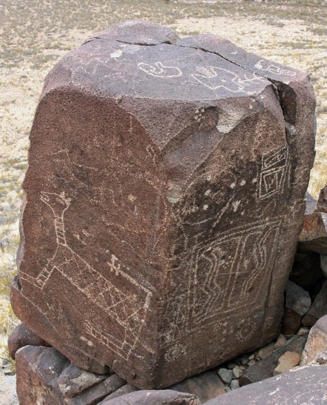
Below a petroglyph rock from Kyrgyzstan.
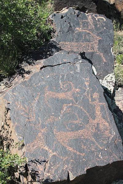
Above other broken parts Petroglyphs nearby the river Koksu in
Almaty Province, Kazakhstan.
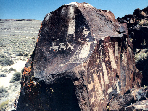
Below a Prehistoric rock carving of deer. Bayankhongor, Mongolia

Below a Oregon Petroglyphs, you notice the damage and also the unnatural surface with the metallic glaze patina.

Above is a flat man made wall with petroglyphs at Deep Canyon Bishop.
Below is the Molen Reef Petroglyphs in Utah. Here you notice that the patina is only on the front side and not on the broken side on the left, which means that the patina is older than the damage of the stone as if it was the weathering that caused the patina it would have been on the whole rock. You notice too that the petroglyph is on a flat surface.
The next one is the Newspaper Rock State Historical Park in Utah. Here it's clear that only the surface that have been engraved is tainted in compare with the rest of the rock. And here it’s the normal position as a kind of monument and not as a damaged rock on the ground.
The next petroglyph is from the lobo-canyon in the Cebolla wilderness in New-Mexico. You see the flat surface and the broken part don’t have the patina..
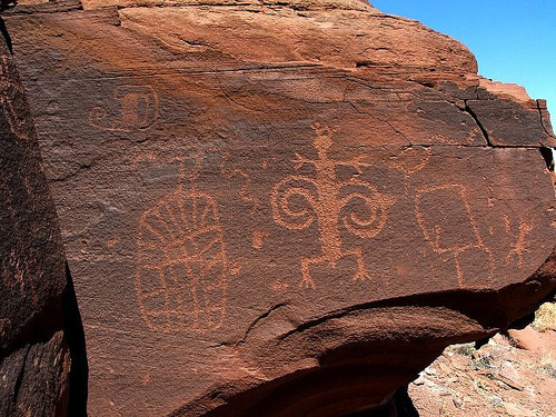
Above the so called Eagles Nest in Jubbah Saudi Arabia, the same flat surface.
Next petroglyph is in Greenwater Canyon as you see at the top left the original level of the rock and beneath parts have been removed to make the flat surface.
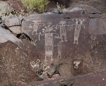
The next petroglyph is from the Rabbit Site. The man made flat surface is clear, also the sign that a tool was used.
Above Rock art at coso range eastern California it seems it was a part of a mountain, but what caused this huge damage which is a pattern in other places far away from each other.
The Petroglyphs below from the Petrified Forest National Park, Arizona.
The block above looks more like a building block.
Above is a Petroglyph in the Petrified Forest National Park, in northeastern Arizona, you see clear signs of damage, the flat surface is man made and clear that it was a part of a bigger construction. Did these rocks fall from the heaven?
Below is the Grapevine Canyon its located in the very southern tip of Nevada below what did such a damage?
Below is a Hopi Rock Art Petroglyph in Navajo Reservation in Arizona
Below a petroglyph in the Anasazi Valley in Utah. Lot of scattered damaged rocks that don’t belong to the geological formation of the area. These rocks look like have been part of one solid structure.

Below a petroglyph in Oregon, you notice the crack.
Below from the Sonoran Desert National Monument Arizona. Another cracked rock.

The Checta Petroglyph IN Peru. The word Checta means ‘broken rock or cracked firewood’ in Quechua, an ancient language still spoken in some parts of the highlands of Peru. The Checta Petroglyphs, discovered in 1925 by the priest Pedro Villar Cordova, are composed of almost 100 rocks, depicting approximately 450 carved images which resemble humans, animals, plants, celestial bodies and other drawings with abstract characters of difficult identification. Most of the petroglyphs face north and northwest.
They are scattered in an archaeological area of about 8000 square meters in Querena Hill at the confluence of Alcaparrosa Ravine with the left bank of Chillon River Valley at approximately 1200m in the District of Santa Rosa de Quives, Province of Canta, Department of Lima, in Peru.
The age of The Checta petroglyphs is uncertain. see image below
Below from French Guiana, Suriname. Stones with petroglyphs showing signs of destruction. You see the patina as elsewhere.
http://www.youtube.com/watch?v=HeyjEM90l1w
Above is the Pilbara area of Western Australia you find such petroglyphs, the same rocks all over the globe, all of uncertain origin or age.
Australia’s thought to be ancient Aboriginal engravings of human-like figures, animals and diverse human faces can be found in the Burrup Peninsula and surrounding Dampier Archipelago
Below from the Acacus Mountains are a range of mountains in the extreme south west corner of Libya in the Sahara.

2) Megalithic structures:
Such structures are found in different places especially in South America and Asia. They are built of silicon based rocks.
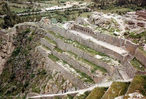
Inca construction below is built on the top of a mountain almost unreachable, it's a bigger part of the destroyed planet.
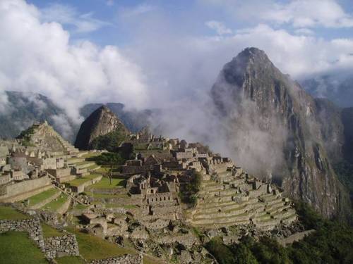
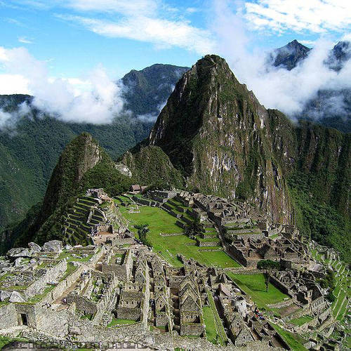
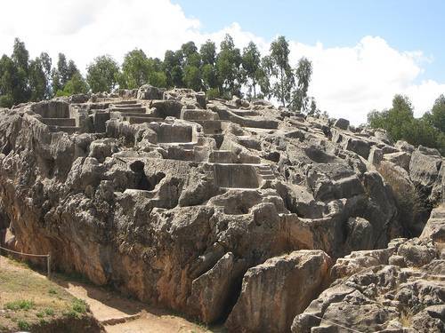
Below is a bird's eye view of Machu Picchu in Peru.
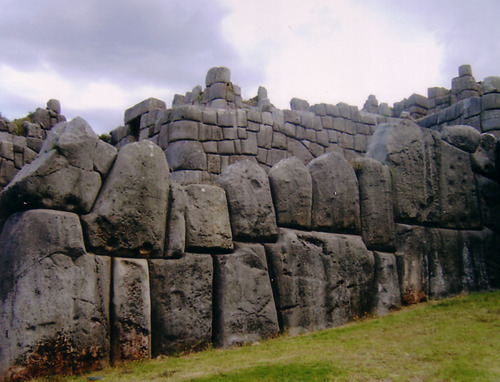
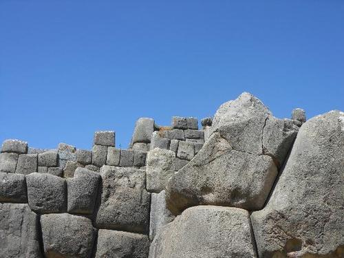
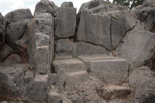
Sacsayhuamán ruins in Cuzco, Peru you notice the similarity with the boulders carrying the petroglyphs
.
Different usage and philosophy comparing the upper part with the older lower part. You notice the Newer buildings on the top of the old once.
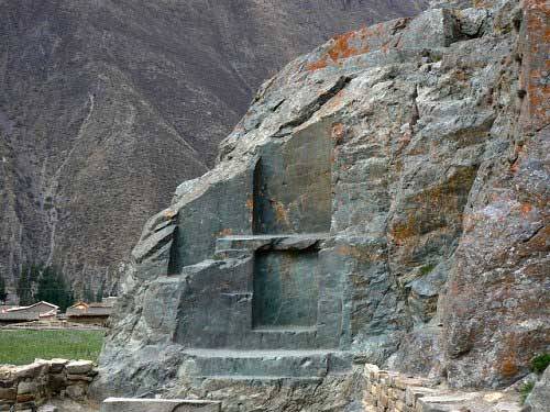
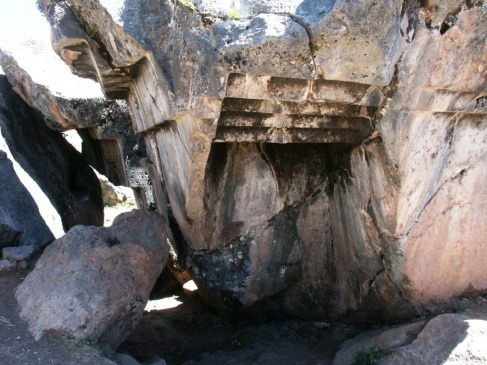
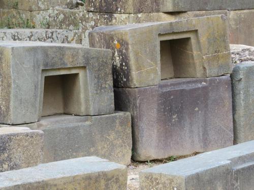
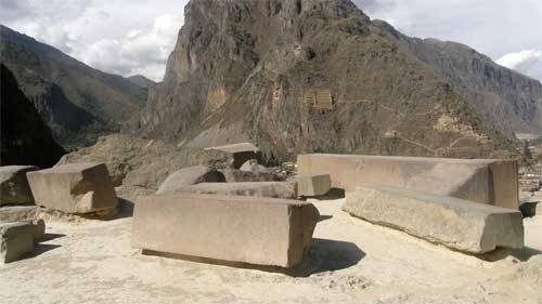
Above the Ollantaytambo monuments in Peru , the upper part of the rock monument is destroyed, what did it? And where are the remain.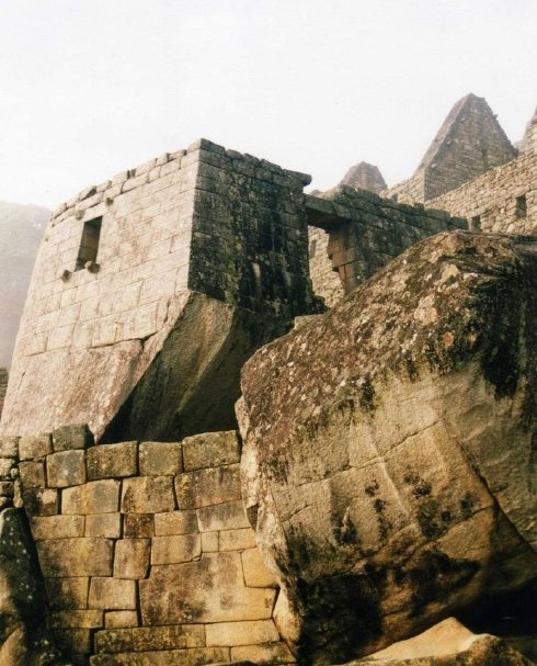
Above in Machu-Picchu in Peru the lower monolithic part is from an older structure turned upside down and you notice the tool marks on the stone. Newer buildings have been added. I think that the structures in Peru have been built on three different stages. The lower part is carved in the rock and impossible to be done in our world, on the top of it are buildings using huge blocks also of sophisticated technology and then buildings using smaller blocks, looks like trying the reconstruct older structure. The last stage could have been done on earth using older stones after been cut in smaller parts, as the low of gravity changed.
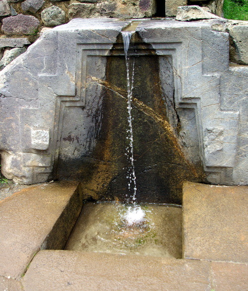
The next image is a part of an older construction which stood probably on its original location in vertical position or was a part of a façade and have been used later as a fountain but the missing parts of such structures will never be find.
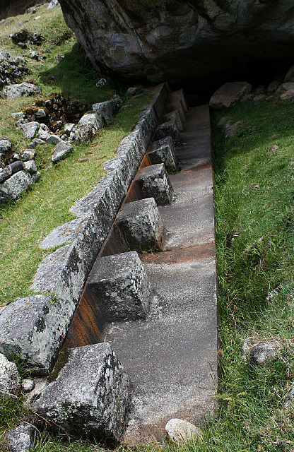
The next image is from Qenko in the Sacred Valley of Peru located in the Cusco Region, Cusco Province. It has a similarity with the Rodadero Smaller-scale configured rocks in Peru include the Sayhuite monolith, a rock with more than 200 geometric and zoomorphic figures near the town of Abancay, and a carved rock at Concacha near Abancay. Similar rock-hewn structures elsewhere in the world include the carved stairs, platforms and caves at Udayagiri/Khandagiri, near Bhubaneswar in India, and the massive underwater monument off the coast of Yonaguni, the southernmost of the Japanese Ryukyu Islands. This kind of similarities should be taken in consideration. The similarity is not only in the structural form but also the kind of stone used, the perfection of the work and the unknown origin, function or age (estimated by the most as much older than thought to be) and also the destruction they suffered. The most of such structures are located on the top of mountains, very remote and due to its size and weight impossible to lift to such high locations. This observation is to be seen in different parts of the world. Specially the next image you see the cracks on the rock. These rocks don’t have the same geological formation like the ground beneath. Such work needs a very advanced technology. These kinds of structures are also impossible to imagine to be used by humans lived in such far ages with the absence of any other artifacts or tools or even any creatures which could be related to them, specially those in Machu Picchu, Cusco and Puma Punku. They are very abstract and timeless. I think they don’t match to the human mental development of the estimated age. The look more like done in the future and not the past.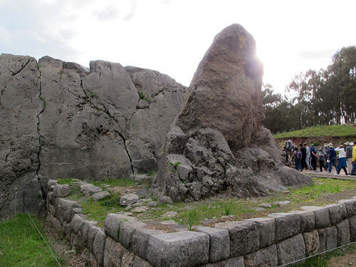
See interesting information:
http://davidpratt.info/andes2.
See more pix http://peruenroute.wordpress.com/2012/01/06/sacsayhuaman-northern-zone-ii/
http://www.world-mysteries.com/mpl_9_vitrified_rocks.htm
The next is a video of the Colina Suchuna, a strange, vitrified rock at Sacsayhuaman, Cusco in Peru. See all the structures that were made in this rock, it looks as if they were pressed into the rock when the rock was soft once. The rock is so smooth that it is used as natural slides. It is considered an Hanan Pacha structure by Jesús Gamarra, also because it is surrounded by walls with perfect fitting stones from the Uran Pacha time. you notice the huge scale of destruction which coldnt be made by human force and there is no reason for. The only logic explanation is that it fall from space.
See more information:
http://www.youtube.com/watch?v=Ly7D_xD-fns
http://home.comcast.net/~georgesaunders/ancient.html
http://www.youtube.com/watch?v=ae_8ri2fiwI
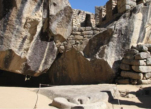
Below a part of the structure built in the rocks turned upside down, obviously part of the twin planet. Below you see the scale of destruction in Machu Picchu. Such a form of destruction can only be explained as a result of a cosmic event as it lays on the top of a mountain like the most of similar cases.
Below is the Sayhuite monolith, the true purpose of Sayhuite is unknown. A rock with more than 200 geometric and zoomorphic figures near the town of Abancay in Peru. As if the structures have been made in softer rocks or clay and it was hardened or petrified after the impact, in the same way like the petrified bones, trees and ground with dinosaur footprints?
Read :
http://www.abovetopsecret.com/forum/thread940634/pg1%26mem=bigfatfurrytexan

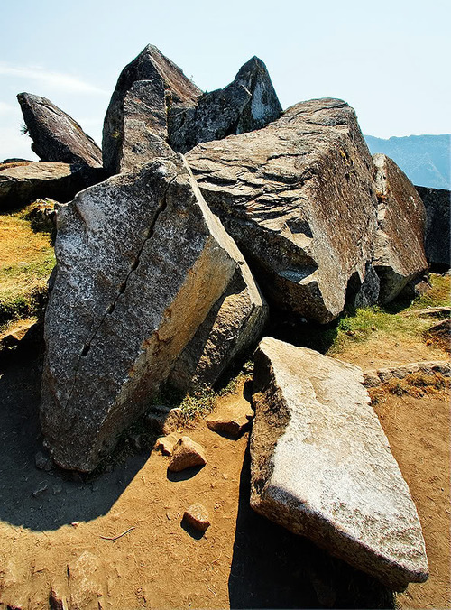
A Sayhuite monolith below, The most amazing was a rock with carved stairways and ascending platforms which is cracked down the center. Clear evidence that it broke after hitting the Earth.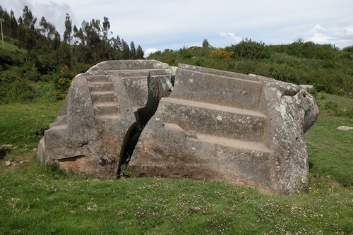
In the next video you see clearly the remains of a structure that have been totally destroyed and there are lots of missing parts, you notice that its on the top of a mountain, what indicates its falling from the sky.
http://www.youtube.com/watch?v=YLe5v3 8v2j0#t=359
The image above is the so called nine seats in Ñusta Hispana archaeological site in the Cusco region in Peru. You clearly see the boulder on the top right hand which means that the damage happened after the construction.
Below another rock that is broken from a bigger one but the other parts are missing.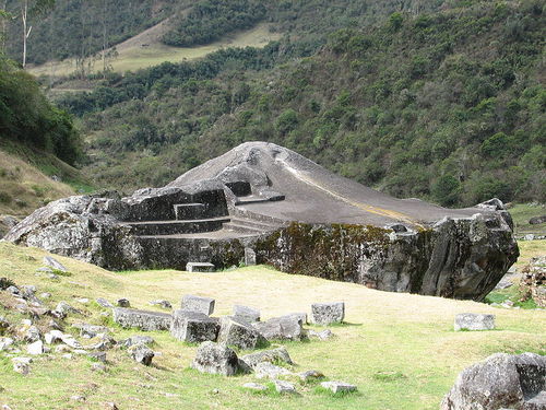
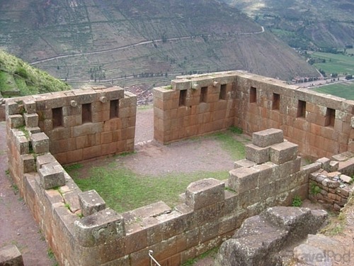
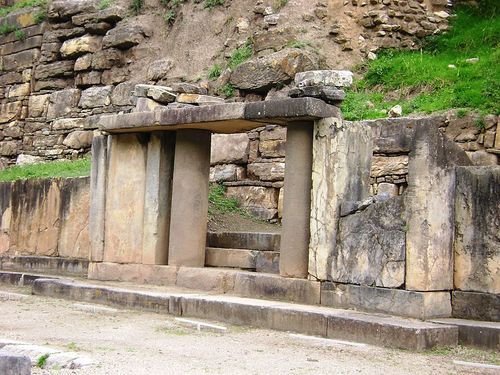
Below is the Ollantaytambo Complex northwest of the city of Cusco in Peru. It is located at an altitude of 2,792 meters (9,160 feet) above sea level. You notice the highly sophisticated form and work that don’t match to the abilities of the tribes that lived in the area later, meant that the Inca are not the original builders. You find similar architectural elements of unknown origin and age all over the world, which means they belong to the same civilization. It is just beyond human known abilities. To have the knowledge and technology must have reflection in the daily life like artifacts, tools or even dress. The newly added parts could match but not the original old once. These parts look like been collected to be reused or considered as sacred ancestor's remains. You see that the next structure was partly removed from a bigger part as the bottom side is showing. The missing parts will never be found or they could have fallen on other parts of the globe or even buried under impact rubble.
You notice above that the structure on the top left hand is just a part of a building the rest is missing. You see windows and a door which means that it was a closed building. The teases and the steps don’t belong to the original structure they have been added later. I think that it stood more likely on a flat surface. This could be the explanation of how getting such stones so high. You see below how a similar structure originally looked like. You should imagine moving such blocks without damaging them even slightly by the edges.
Watch the next video; it’s a Google Earth 3D Model of Machu Picchu. Here you see that it's impossible to have had the same topography when building the original structure.
https://www.youtube.com/watch?v=YI6M9LC4Pn0
You see on the next image the technical ability of the followers. By comparing the walls and the size of stones used. You see how they used older big blocks on the top of the doors.
The next image are the remains of the Temple of the Sun. You see the fallen stones after the impact scattered on the ground. You see the perfect work by now mean comparable with the newer one.
The next image to show what I mean by original and new work.

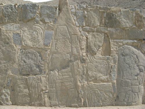
The next image is from Chavin in Peru were you notice that this block is just a part of a complex that have been severely damaged like the most similar remains of the so called lost civilization all over the world. You notice that newer parts have been added but complete different style and technology.

Another image below from Chavin showing the usage of some stones to build other ones where we notice that even the columns have different sizes. The answer is where the remains of all these perfect structures are and why couldn’t the followers using the same techniques to build the newer ones? We can compare these blocks with the others in the background.
Another picture from the same monument showing the worship of an older mysterious stone and the difference in the quality of work building the other walls. In this case I am not going to try to explain the meaning or function of the stone or what the image represent as it is almost impossible to use our logic which is for sure complete different than theirs, that is the matter with all these remains that belong to these so called lost civilizations taking in consideration the difficulty of dating of the original parts. But the question is how far were the two builders related? Sometimes I ask myself if they were done by human beings, or could dinosaurs have had the mental ability to achieve such structures? Was there a kind of coexistence between the both? Was that on the twin planet that hit the earth? I think it would be much easier to move such heavy stones under a lower gravity on another planet than under the same gravitational condition on our planet.
Another interesting place is the Chavin archaeological site in Peru; it was the capital of a pre-Incan culture, estimated to be ~4000 years old. What to be noticed is that the wall have been but together using stones that belonged to another structure and much older. A possibility is that the builders tried to reconstruct a structure that was heavily destroyed. You notice on the next image that heads have been put over each other. That could have happened 4000 years ago but the original structure was much older. I am even not sure if it was a structure or just a wall of a mountain.

The next image is from Guatemala from the mask temple of Lamanai that belongs to the Maya civilization. You have to notice that the temple have been added to the heads which belong to other damaged structure. The stones used to build the temple are smaller and show different workmanship than the heads. I think that the Mayans thought that they belonged to gods and constructed a temple around them.

Not far from the mask temple is the jaguar temple, in the next image you see parts with ornaments made from bigger stones and more complicated work have been added to rather simple structure built from smaller stones, which means that they are younger. Notable are features and the similarity with the Olmec heads.
The next image is of statues beside the Xia royal pyramid shaped tombs found near Yinchuan Ningxia province in Inner Mongolia in China. where you find feature similarities with other parts in the world. To be noticed that it is just parts of statues. These are 2 of 9 stone kneeling statues. The material and style don’t match with the tombs. It looks like have been collected and adopted in to the site. The site is a flat plateau surrounded by mountains. The statues don’t belong to the geological rock formation in the area. The building and tombs are made mainly from clay. Not using the same rock means that they don’t belong to the same structure.

Watch interesting videos:
https://www.youtube.com/watch?v=ae_8ri2fiwI
https://www.youtube.com/watch?v=x81-5SWVtUQ
See Top 10 Inca Ruins
http://travel.nationalgeographic.com/travel/peru/machu-picchu/inca-ruins-photos/#/huchuy-cusco_36197_600x450.jpg
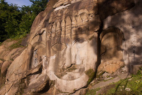
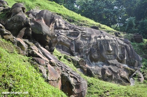
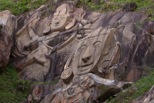
We make a move to Asia where we notice a similar pattern of destruction which means that that event was a global one that hit the earth and wiped-out the existing civilization. The next image is thought to be a head of the Indian god Shiva at Unakoti. The head is 30 feet high without crown. The worshipers invented stories to explain the creation and destruction of these structures. The legend say that the god Shiva was going to Kashi with accompanied by other gods and goddesses, t hey made a night halt at this location. He asked all the gods and goddesses to wake up before sun rise and proceed for Kashi. It is said that in the morning, no one else except Shiva himself could get up so set out for Kashi , he cursed the others to become stone images, a naive legend just to explain the cause of destruction happened to these structures and not knowing the origin of them and its purpose. The destruction and the kind of stone is remarkable and shows a pattern of damage that is found in many parts of the globe.
Watch: http://www.youtube.com/watch?v=qwwGc6k2sxI
Below you have some monolithic structures found in Japan in the Asuka district, the purpose is completely unknown, the name is Wine-Ship-Stone very similar to those foundin Peru, even the same stone.
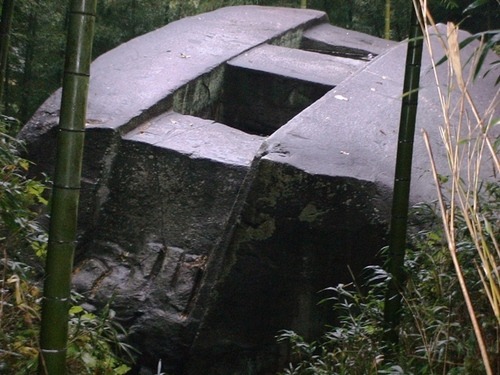
Above a carved granite stone the so called Masuda no iwafune found near the village of Asuka in Japan . 11 meters in length, 8 meters in width, and 4.7 meters In height. How or why this colossal stone and others was carved remains a mystery. They appear to be a different style than later Buddhist sculptures was found on top of a hill. Nearby the tomb of Ishibutai Kofun which is built from massive boulders including one that weighs an estimated 75 tons, but this tomb was built by using stones from other structure and shows no special technology like in the case of the called Masuda no iwafune which is a perfect work and of unknown purpose.
Below The Oni-no-Manaita Stone (The Devil’s Chopping Board) is on a small hillside to the east of the Mausoleum of Emperor Kinmei. An enormous granite rock of approximately length 4m, width 2m, and thickness 1m,
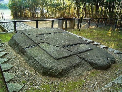
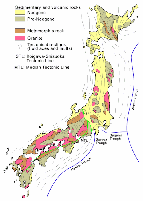
The geological map above shows the granite spots, the most of the old sacred stones lay on hills positioned on these spots.
An incredible discovery that was recently made in Russia threatens to shatter conventional theories about the history of the planet. On Mount Shoriya in southern Siberia, researchers have found an absolutely massive wall of granite stones.
Some of these gigantic granite stones are estimated to weigh more than 3,000 tons, and as you will see below, many of them were cut with flat surfaces, right angles, and sharp corners.
Nothing of this magnitude has ever been discovered before. The largest stone found at the megalithic ruins at Baalbek, Lebanon is less than 1,500 tons.
-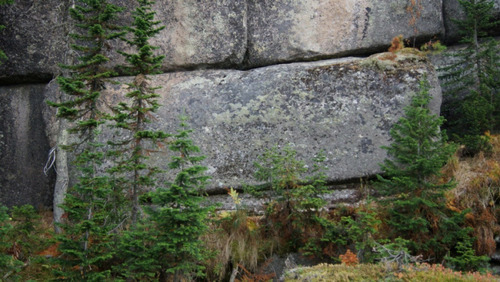
The next one is called the Russian-Stonehenge-Megalith-huge-block mysterious stones are found on the Mountain Shoriya in the Kemerov region of Russia.
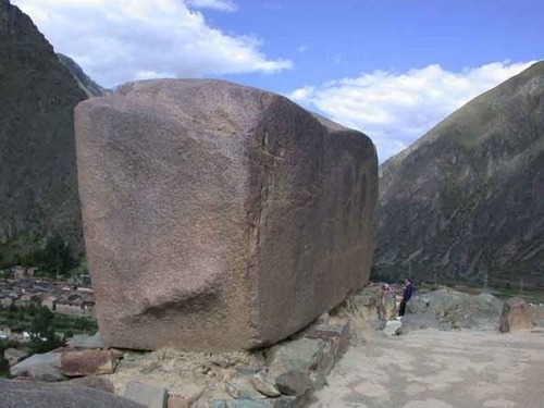
See more at: http://humansarefree.com/2014/03/megalithic-site-discovered-in-russia.html#sthash.xwHl4YGG.dpuf
The next t image from Russia Pedan (Pidan) Mountain, Primorsky - wall-corner
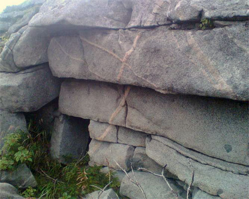
3) Signs of great destruction to structures that stood on the twin planet:
I noticed that this destruction is world wide and caused by a huge force and it must have happened by the same event.
Most of the monolithic structures show signs of destruction and missing parts, the same is noticed on the stones carrying petroglyphs that they were parts of bigger structures. In the case of Egyptology when finding such stones, the first thing to do is to look for missing parts and try to put them together. But in the case of such an impact lots of those stones fall scattered on different parts and some are buried under bigger rocks. What is to noticed is that the most such structures lay on higher places and mostly on the surface and not buried deep in the ground. But we must imagine the size of the missing structures compared with the little remaining parts, or how it looked like when it was comlete.
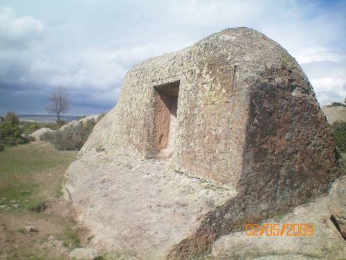
Above the Büyük Kapı Kaya Turkey a part of a damaged granite structure in a place formed of limestone of unknown origin or age, probably a part of the twin planet.
Below two images also from Turkey in Afyonkarahisar-ihsaniye. It's one of the best examples for the damage done by the impact. You see the cracked rock with the damaged parts and you see the fallen one. You see that the damage was not in one place it was the same all over the globe. Such a crack can be only caused by hitting the ground or that the earth was hit violently.

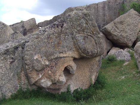
Below another part of a structure in the Midas Monument in Central Anatolia Region, Turkey. The rest of the structure is missing.

Remains from the same structure, you notice that it was a part of a mountain and not a building. Remains of the patina like in other places and also the same flat surface like in the case of the remains with the petroglyphs in the Americas. You notice that they are turned upside dowen.
On the rocks above you see the man made flat surfaces; it's from the same area.
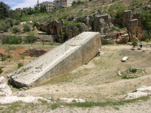
Above the Baalbek Stone in Bekaa Valley in Lebanon huge granite block unknown origin or purpose, no other parts found (no sign that it was a part of a structure). What could be noticed is the crack to the right exactly in the place between the part under the ground surface and the part above the ground; this happened when this part hit the earth and broke.
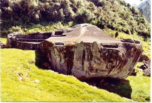
Above is the Yurak Rumi the sacred white rock shrine in Peru. It looks like have been brocken from a bigger part but were is the other part or parts?It looks like it could be moved but the huge size makes it impossible. Its another clear evidence that this is one of many parts that it belonged to the twin planet and fall on Earth after been destroyed.
Below in Seri Lanca all the same thrones and grounds (there are also more of them) had been cut from the whole, unbroken body of huge granite boulders. We see the similarity with the Yurak Rumi above. they look like parts belonging to the same structure but fell on two different parts of the globe.
Below clear impact cracks in Qenko in Peru.

The next images show The Gate of the Sun in bolivia before restauration and after. We notice clearly the crack caused by the impact.
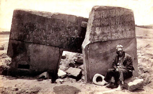
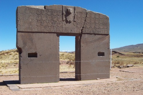
Below is an another example from the same site.
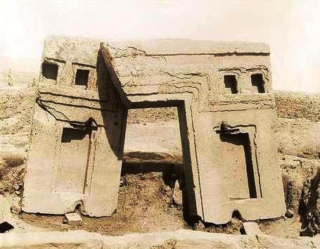
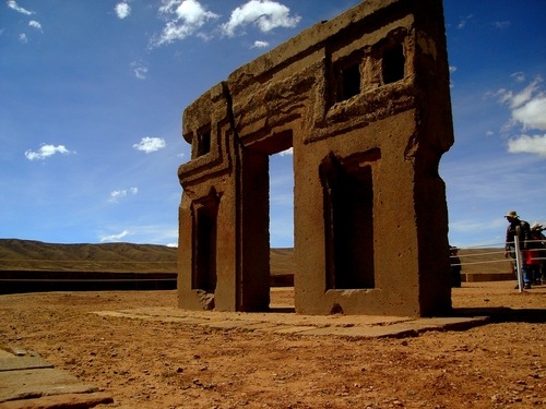
Below is the Udayagiri and Khandagiri Caves are manmade caves of archaeological, historical and religious importance near the city of Bhubaneswar in Odisha, India. Notice Similarity with Peru. But the whole is a part of older unknown structure which was badly damaged.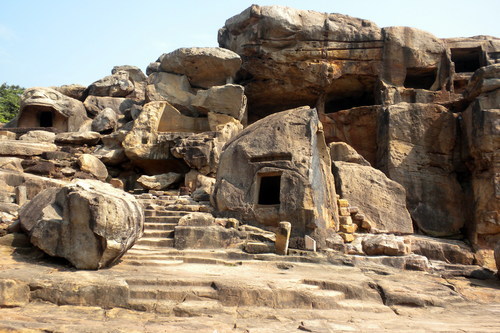

The cave above is carved in the giant head which is much older.
Remains of the surface of the twin planet and of the civilization that existed on the Earth before the collision:
In the next part I am showing visual evidence in photos in videos where its clear that some of these monuments are parts of a planets crust with evidence of extraterrestrial civilization. These parts are now plateaus with missing parts. What we see in south America on the top of the mountains is not the original geography, these ruins were standing on rather flat surface of the twin planet, but when the twin plant was destroyed these parts formed mountains on our earth but they formed smaller plateaus. Some parts were turned upside down therefore there are missing parts which disappeared under the mountains. The geology and topography of the Earth changed totally. The Earth turned from rather flat and watery planet to a planet with irregular mountain surface. Some of the images are from the original earth which had its own civilization. These are the parts found on flat lime stone plateaus like in china and in the west of Peru as the satellite images are going to show. Below at the Pueblo Bonito Chaco canyon a clear evidence that the impact event happened after building the structure, a part have been damaged and huge rocks even fall inside the structure. You notice on the other image that a part of the plateau was uplifted and the rocks fall after the uplifting.
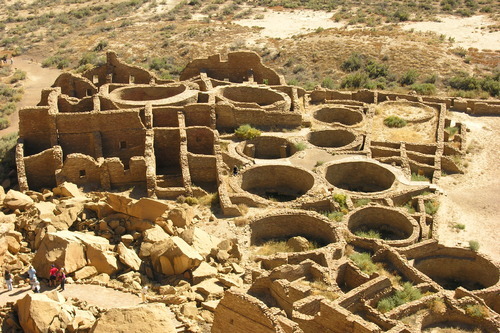
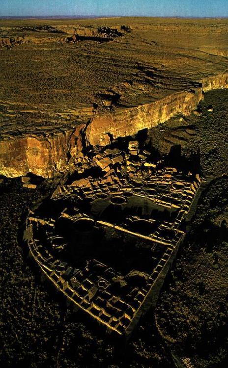
A place were I find a combination geological mystery and remains of a lost unidentified civilization is the Fajada Butte in Chaco Culture National Historical Park in northwest in New Mexico. It rises 135 meters above the canyon floor. Although there is no water source on the butte, there are some ruins of unknown purpose in the higher regions of the butte. Remains of a 95-meter-high, 230-meter-long ramp have been found on the southwestern face of the butte as seen below.
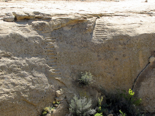
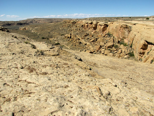
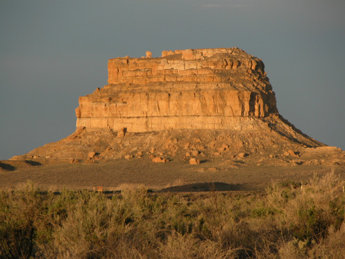
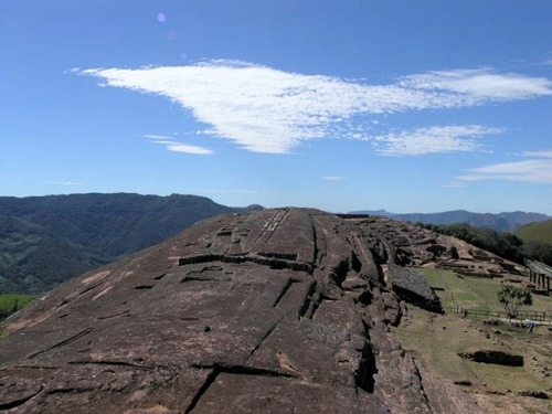
El Fuerte de Samaipata is a unique archaeological site in the mountains of central Bolivia, the caving is on the top of a mountain it seems to be a part of a bigger missing structure.
Above in Cusco in Peru unexplained stone another evidence that it was the surface of another planet, otherwise where are the missing parts of that structure.
A video showing Sacsayhaman in Peru from the air were you notice clearly that it was just a part of a bigger planets surface, where you notice clearly that there are missing parts:
http://www.youtube.com/watch?v=QVSmX1OVtlw
Machu Picchu from the air:
http://www.youtube.com/watch?v=PIZqBQ_R0LU
You find similar unexplained structures in Japan structures, same stones like Peru and unexplained damage.
Below is Sacsayhuaman, Cuzco in Peru
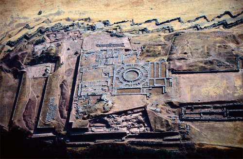
Below thought to be Anasazi Ruins, Chimney Rock Archaelogical Area. You notice the similarity with other ruins built on the top of a flat sand stone mountain. Looks like a part of once bigger plateaue. 37°11'30.26"N107°18'23.32"W
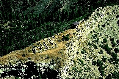
Below is a Nuraghi near Arzachena (Northern Sardinian Nuraghes, Southern Sardinian Nuraxis .The function is unclear some say a worship place some say a fortress others say rulers residence. They are found on top of hills. Its origin and age is unclear thought to be about 1,500 B.C. many say they are much older.
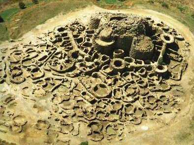
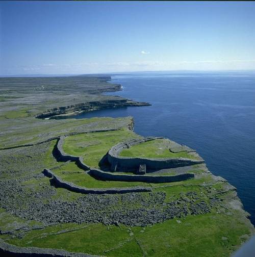
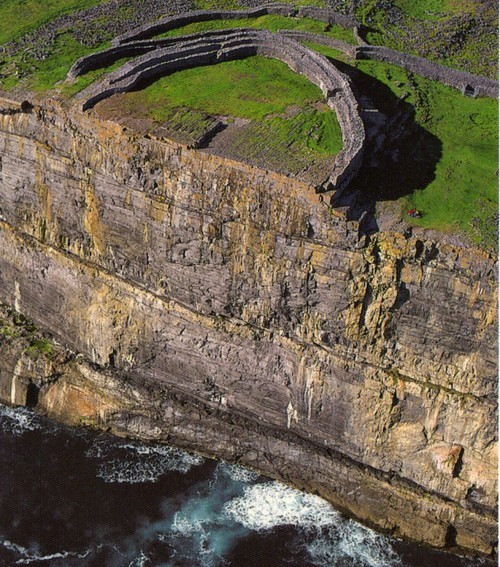
Above is a circular structure in the Aran Islands Landscape in Ireland. Built on the edge of a plateau, it seems that the second half is missing. It could be an uplifted part of a plateau.
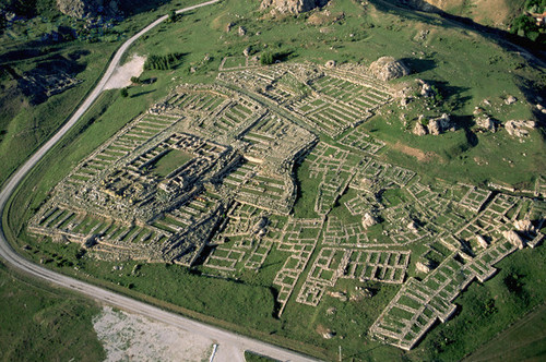
Above is the city of Hattusa, in central Anatolia, is thought that the last-known Hittite king, Suppiluliuma II 1207 B.C. built it. There is not enough evidence about that. It was destroyed and abandoned sayed by fire, but the real reason isn’t known. According to my theory it was destroyed by the impact. It has the same features like a lot of sights that suffered the same fate. It lies on a flat uplifted plateau. Impact bodies or rocks that struck the site are visible. Hattusas was not the only city to be destroyed by fire at this time, as other cities of Central Anatolia appeared to have met the same fate: Alaça Hoyuk, some 25 Km to the North, also perished in a fiery catastrophe; Hittite palaces at Masat and Fraktin, as well as the fortified citadel of Karaogan, near present day Ankara, were also burnt to the ground in catastrophic fires.what is confusing me about this city is that there are two different construction types, one very monolithic and similar to the once in Peru shown in the next image and the other is a very simple one. Therefore I think that the city which have been destroyed was not the Hittite city but the original one or both have been destroyed but not the same event. There have been found large number of perfectly circular drill-holes cut deep into the granite rock as if by a tube drill. There you find the evidence of the presence of two different civilizations. below is the upper Hattusa city, I think that originally both were on the same level. You have then an imaginary reconstruction of the city which look like other circular cities that belonged to the lost civilization. You have two images showing the similarity with the Inca structures, the second one has reliefs on it but it is clear that these images don’t belong to the same structure. They are primitive to be compared to the elegancy and harmony and simplicity of the monoliths. The proportions are rude. Normally the whole wall would be decorated and not only a part. Here there is an attempt to imitate the Egyptian style.

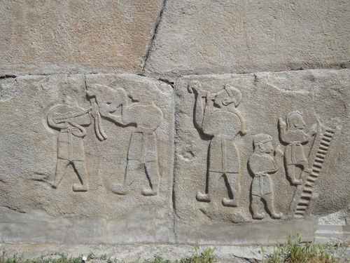
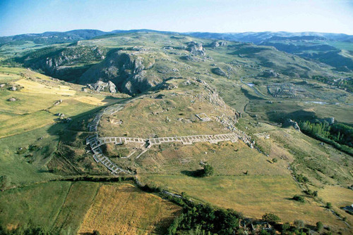
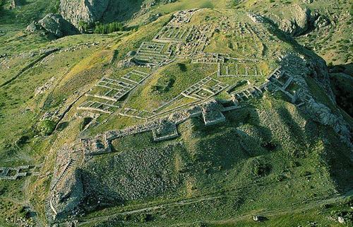
On the first image you see both cities the upper and the lower Hattusa. You notice that the impact affected the ground with the construction on it. The builders would have leveled the ground before building such a complex structure. You see also on the aerial views below the deformation of the surface.

Above you have clear evidence that the site have been hit by fallen boulders. This kind of destruction is a pattern noticed in all prehistoric lost civilization.
The next footage is the Chankillo ruins, near the Peruvian coast
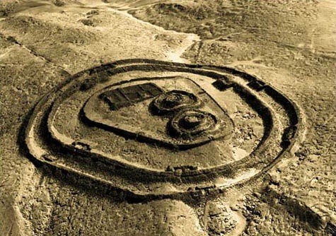
Some remains are easier to find as they are in desserts and have been protected by dry weather but some lay in tropical regions and have been damaged by floods and rain or hidden under jungle plants, other suffered from human activities.
Lots of lost cities are thought to exict and are hidden and undiscovered in different parts of the world. We have the Palenque in Mexico, the ruins in the Llanganates National Park in Ecuador, some discoveries have been made in the Amazon Basin and the Angkor in cambodia.Like the recently discovered remains of a major archaeological site deep in the jungle mountains in Colombia known as Cuidad Perdida (the lost city) in the Sierra Nevada de Santa Marta. As shown below:
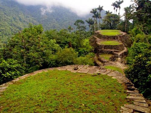
Another newly discovered city is Tak'alik Ab'aj, it is a pre-Columbian archaeological site in Guatemala.
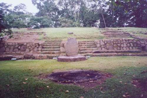
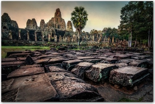
I wrote a theory about the extinction of dinosaurs and I came to the conclusion that the dinosaurs didn’t live on earth but on an another planet, a twin planet or moon that have been either captured by the gravity of earth or most probably hit by an asteroid or comet that destroyed it and pushed it to change its orbit and collide with the earth. That impact was not only the cause of the extinction of the dinosaurs but also the petrification of the dinosaurs and trees that existed on that planet. That twin planet was formed mainly of silica based rocks like Granite and Sandstones and was hit by another huge space body (probably Granite) which pushed it towards the earth. That twin planet could have been a moon. That twin planet was probably smaller and had another atmosphere and gravity. Due to the impact the planet was destroyed to pieces and was scattered on the earth, in the form of mountains and boulders.
You can read about this theory at:
http://dinosaursonthetwinplanet.tumblr.com/
I noticed that a lot of these scattered boulders are engraved with petroglyphs which are scattered on different spots on earth. I also
noticed the large scale of global violent destruction of all monolithic prehistoric structures. I noticed that the most of those structures have a kind of similarity and the most of them are of unknown origin and they don’t have much to do with the groups of people inhabiting the same area, at least from the technological point of view. I think that it's wrong to look at these structures or civilizations every one as a separate case, there must be something common connecting these civilizations. It's not just the standard or degree of that civilization but also the age they belong to with the great difficulty facing the date confirmation. I date these civilizations to the period before the Younger Dryas impact hypothesis or the Clovis comet hypothesis 12,000 and 13,000 years ago. Not finding the crater of that impact led me to the idea that the twin plant collision was what the scientists are looking for. A large scale of destruction that wiped out not only the advanced civilizations but also almost the complete human race. Some basic differences in the remains of these lost civilizations led me to the idea that the reason wasn’t a time difference but probably different human race. This collision have changed the topography and geology of the earth, which could have miss led the scientists to invent the plate tectonic theory. I found huge amount of data and information that could support my theory. I started to look for global signs that are related to such a catastrophe. This observation led me too to the idea that the twin planet could have been inhabited not only with dinosaurs but also a human form living side by side. There is a lot of evidence for this theory:
1) The most of the boulders containing the petroglyphs look like been badly damaged, you notice cracks as an indication of a distraction caused by a great force like by the impact, that damage can be seen on the most rocks in the area.
2) There are missing parts from the rocks containing the petroglyphs, that’s an indication that these petroglyphs where done before its distraction and not just done on boulders lying on the ground here and there. They were probably a part of a wall that was full with petroglyphs which stood in a vertical position.
3) The surface behind the petroglyphs have been made flat to curve the petroglyphs , the same like the petroglyphs walls of grand canyon and others, the walls where made flat before curving or painting. It’s a sign that it was a part of a bigger planed construction work or worship ceremonial place.
4) The dark red brownish patina on the stones looks rather man made than caused by erosion on the contrary it looks sometimes that the weathering affected the patina and damaged it, the same glaze can be seen on some built walls in Peru.
5) The similarity between the petroglyphs all over the world despite of the different location sometimes thousands of kilometers apart with the appearance of certain symbols in different parts of our world which indicate that they had a common origin and location.
6) The appearance of dinosaur like creatures images that lived eventually side by side with these humans.
7) The existence of some stone structures that don’t match to the geology of the surrounding rocks and suffered of great unexplained distraction.
8) These structures don’t match to the supposed time they have been erected (too sophisticated for such periods) and cause a great confusion and unsolved questions about their origin and dating some are dated to 20000 years ago and don’t match to the supposed primitive state of humans at these early ages.
9) The boulders and the stone structures have the same geological origin either granite or hard sandstone (ignitions or silica based rocks) where ever you find them.
10) The existence of the huge structures on the top of high mountains raising the question about how they have been brought to these heights, they are very remote places very hard to develop such a civilization. Such an environment is rather an obstacle for creating such civilization.
11) Lot of the blocks containing petroglyphs look like the blocks used in the Inca buildings, like Machu Pitcho and other parts in South America and Asia and even the same stones and technique.
12) The existence of petrified extinct dinosaur and tree fossils near the petroglyph places means that they are connected in some way.
13) Some consider these remains done by aliens due to the unexplained symbolism and the precision of the construction and the illogic weight of the stones which is raising the question about the kind and origin of the civilization that erected such monuments which indicate a different logic than the systematic way of thinking on earth.
14) These places have a different flora and fauna than other places, could be species that survived the impact. You find some forms of life which could be related to the dinosaurs.
15) These structures are dated between 15000 and 20000 years ago and they indicate a highly developed civilization on different parts of the world, but the evidence found from the same period indicates that the standard of the human civilization and development on earth at that age of wasn’t that sophisticated, as the remains (like tools) indicate rather primitive stage and way of living, which makes the two cultures don’t match together.
16) The ignorance of the inhabitants of these areas of the real history and origin of these structures.
17) The finding of human remains like big skulls and skeletons which could be related to other circumstances than on the earth and even the DNA is different.
18) Finding skeletons which have a different anatomy specially the sculls which are not typical for humans and mostly in Peru not far from the mysterious structures.
19) There are in almost every civilization literatures and tales about facing a great catastrophe and floods.
20) Wide range evidence of o global catastrophe that ruined a prehistoric civilization that existed on earth simultaneously.
21) Many granite boulders are showing impact signs, like being split in two parts.
I am going to explain these points using some photography and links.
Impact evidence:
All the extinction events are related to the same event and same age. The Younger Dryas event which had parallels in other parts of the earth
Did some survive the impact and left to Egypt and not the reverse way as thought?
Something dramatic happened about 12,900 years ago, and the continent of North America was never the same. A thriving culture of Paleo Americans known as the Clovis people, vanished seemingly overnight. Gone, too were most of the largest animals on the
Continent -- horses, camels lions, mammoths, mastodons, saber-toothed cats, ground sloths and giant armadillos.
Scientists have long blamed climate change for the extinctions, for it was 12,900 years ago that the planet's emergence from the to a halt,
reverting to glacial conditions for some 1,500 years, an epoch known as the Younger Dryas.
In just the last few years there has arisen a controversial scientific hypothesis to explain this chain of events, and it involves an
extraterrestrial calamity: A comet, broken into fragments, turning the sky ablaze, sending a shock wave across the landscape and scorching forests, creatures, people, and anything exposed to the heavenly fire. Now the proponents of this apocalyptic scenario say that they've found a new line of evidence: "nano diamonds." They say they've found these tiny structures across North America.
in sediments from 12,900 years ago, and they argue that the diamonds had to have been formed by a high-temperature high-pressure event, such as a cometary impact.
Geological evidence:
There is a lot of research about an impact but the problem is not finding the body. I think that a part of this body are the granite mountains and boulders every were over the globe.
Was the collision the reason for the mass extinction in America and the climate change12900 years ago?
Was the collision responsible for the ancient super volcanoes near the Utah-Nevada border?
Was the collision the cause of the ice age?
Was the collision the cause of the Chicxulub impact crater buried underneath the Yucatán Peninsula in Mexico? Was it the reason of Chicxulub mass extinction?
several other craters of around the same age as Chicxulub have been discovered
http://www.sci-news.com/geology/science-supervolcanoes-utah-nevada-01612.html
http://www.ljmu.ac.uk/NewsUpdate/viewarticle/1451/
Nano-diamonds and other exotic impact materials have been unearthed in thin sediments, Science magazine report.
The age of these materials coincides with the start of a millennium-long climate cooling event known as the Younger Dryas (named after the pollen-record of the beautiful mountain plant), - some 13,000 years ago.
Many large animals vanish from the archaeological record at this time.
It is also the period in Earth history that sees the demise of Clovis culture - the prehistoric hunters that many regard as the first human occupants of North America. Read more:
http://en.wikipedia.org/wiki/Younger_Dryas_impact_hypothesis
http://www.skepticalscience.com/news.php?n=1345
The new analysis with TEM, confirmed an abundance of diamonds in carbon spherules - melt material that forms in a fraction of a second - and the identification of lonsdaleite, or hexagonal diamonds, associated with meteorite explosions The sheer number of diamonds - up to a million times that found in neighboring sediment - and their presence inside spherules refutes the speculation that the material is the normal rain of meteorite debris, says Allen West, a retired geophysicist in Arizona and a co-author
There is no other way that hexagonal diamonds could have ended up in a carbon spherule in this number.
The absence of some traditional impact material and visible craters in North America led researchers to speculate that a meteoroid or comet disintegrated before exploding in a cluster of airbursts.
Researchers argue that the airbursts could have triggered a series of dramatic climate shifts - including colder temperatures and an abrupt change in vegetation - that would have made survival difficult for large mammals and the Clovis hunters. The cause of the disappearance of Clovis culture and mega fauna has long been and still is a debate.
Skeptics of the impact theory are not won over by the latest data. While scientists agree that something dramatic occurred on Earth 12,900 years ago, the theory that it was an exploding space rock has been cast by some as long on dramatic flair, short on
Impact theorists maintain that the diamonds peak in abundance in the impact stratum.
http://news.bbc.co.uk/2/hi/science/nature/7808171.stmthere
http://www.dailymail.co.uk/sciencetech/article-2158054/Scientists-discover-evidence-meteorite-storm-hit-Earth-13-000-years-ago-killed-prehistoric-civilisation.html
A nearly 13,000-year-old layer of sediment buried in the floor of Lake Cuitzeo in central Mexico contains an exotic assemblage of materials, including nano diamonds, that are the result of a cosmic body hitting Earth.
http://www.futurity.org/nanodiamond-dust-points-to-cosmic-collision
Research shows that a period of rapid cooling in the late Pleistocene 12,800 to 11,500 calendar years ago
http://wattsupwiththat.com/2012/06/19/the-intriguing-problem-of-the-younger-dryaswhat-does-it-mean-and-what-caused-it
The cause of these remarkably sudden climate changes has puzzled geologists and climatologists for decades and despite much effort to find the answer.
The Younger Dryas return to a cold, glacial climate was first considered to be a regional event restricted to Europe, but later studies have shown that it was a world-wide event.
Radiocarbon and cosmogenic dates of the Younger Dryas all over the world indicate the cooling was globally synchronous.
The material evidence supporting the YDB cosmic impact hypothesis spans three continents, and covers nearly one-third of the planet, from California to Western Europe, and into the Middle East. The discovery extends the range of evidence into Germany and Syria, the easternmost site yet identified in the northern hemisphere. The researchers have yet to identify a limit to the debris.
Because these three sites in North America and the Middle East are separated by 1,000 to 10,000 kilometers, there were most likely three or more major impact/airburst epicenters for the YDB impact event, likely caused by a swarm of cosmic objects that.
Such a result should support my theory about the collision.
http://wattsupwiththat.com/2012/06/13/new-evidence-of-younger-dryas-extraterrestrial-impact
another impact evidence is that the sand stone is over laying the limestone. Nubian Sandstone in Arabia
In Lebanon, Anti-Lebanon and Hermon it is underlaid by Jurassic limestone. In Western Sinai, Nubian sandstone rests on Carboniferous limestone, and by the Dead Sea on Cambrian limestone.
http://s8int.com/WordPress/2009/09/28/pteranodon-on-a-stick-egyptian-was-scepter-creature-no-mystery-without-darwinian-history
I think that the sand stone is also of an extraterestrial origin. It was one of the main components of the twin planets.
There are different collision theories
The one of Zecharia Sitchin.theory
Which says that a planet called Nibiru which had a long, elliptical orbit collided with the planet Tiamat which was located between Mars and Jupiter. The collision supposedly formed the planet Earth, the asteroid belt, and the comets. Sitchin states that when struck by one of planet Nibiru's moons, Tiamat split in two, and then on a second pass Nibiru itself struck the broken fragments and one half of Tiamat became the asteroid belt. The second half, struck again by one of Nibiru's moons, was pushed into a new orbit and became today's planet Earth.
My theory has some similarity, it says that these hypotheses happened directly to the earth. That planet or space body (Niburu) hit an earth's moon or a nearby small planet, destroyed it and forced it towards the earth.
The parts that hit the earth didn’t fall instantly on the earth but it took some time till all the parts hit the earth.
Another theory that proves unexpected cosmic events could have hit the earth once, it says that a gamma-ray burst may be the cause of an intense blast of high-energy radiation that hit the Earth in the 8th century.
http://spaceref.com/astronomy/neutron-stars/did-an-8th-century-gamma-ray-burst-irradiate-earth.html
Then we have the giant impact hypothesis states that the Moon was formed out of the debris left over from an indirect collision between the Earth and an astronomical body the size of Mars called Theia, approximately four and a half billion years ago.
It is known that Venus experienced giant impacts during its formation.
We have even the biggest debate about the Chicxulub Crater.
William F. Bottke, David Vokrouhlický, and David Nesvorný, argued that a collision in the asteroid belt 160 million years ago resulted in the Baptistina family of asteroids, the largest surviving member of which is 298 Baptistina. They proposed that the "Chicxulub asteroid" was also a member of this group. The connection between Chicxulub and Baptistina is supported by the large amount of carbonaceous material present in microscopic fragments of the impactor, suggesting the impactor was a member of a rare class of asteroids called carbonaceous chondrites, like Baptistina. According to Bottke, the Chicxulub impactor was a fragment of a much larger parent body about 170 km (110 mi) across, with the other impacting body being around 60 km (40 mi) in diameter. In 2011, new data from the Wide-field Infrared Survey Explorer revised the date of the collision which created the Baptistina family to about 80 million years ago. This makes an asteroid from this family highly improbable to be the asteroid that created the Chicxulub Crater, as typically the process of resonance and collision of an asteroid takes many tens of millions of years.
In 2010, another hypothesis was offered which implicated the newly discovered asteroid P/2010 A2, a member of the Flora family of asteroids, as a possible remnant cohort of the K/Pg impactor.
In 2013, it was suggested that the impactor may have been a comet.
The Chicxulub Crater lends support to the theory postulated by the late physicist Luis Alvarez and his son, geologist Walter Alvarez, that the extinction of numerous animal and plant groups, including dinosaurs, may have resulted from a bolide impact (the Cretaceous–Paleogene extinction event). Luis and Walter Alvarez, at the time both faculty members at the University of California, Berkeley, postulated that this enormous extinction event, which was roughly contemporaneous with the postulated date of formation for the Chicxulub crater, could have been caused by just such a large impact. This theory is now widely accepted by the scientific community. Some critics, including paleontologist Robert Bakker, argue that such an impact would have killed frogs as well as dinosaurs, yet the frogs survived the extinction event. Gerta Keller of Princeton University argues that recent core samples from Chicxulub prove the impact occurred about 300,000 years before the mass extinction, and thus could not have been the causal factor.
The main evidence of such an impact, besides the crater itself, is contained in a thin layer of clay present in the K–Pg boundary across the world. In the late 1970s, the Alvarezes and colleagues reported that it contained an abnormally high concentration of iridium. Iridium levels in this layer reached 6 parts per billion by weight or more compared to 0.4 for the Earth's crust as a whole; in comparison, meteorites can contain around 470 parts per billion of this element. It was hypothesized that the iridium was spread into the atmosphere when the impactor was vaporized and settled across the Earth's surface amongst other material thrown up by the impact, producing the layer of iridium-enriched clay.
In recent years, several other craters of around the same age as Chicxulub have been discovered. Examples include the disputed Silverpit crater in the North Sea and the Boltysh crater in Ukraine. Both are much smaller than Chicxulub, but are likely to have been caused by objects many tens of metres across striking the Earth. This has led to the hypothesis that the Chicxulub impact may have been only one of several impacts that happened nearly at the same time. Another possible crater thought to have been formed at the same time is the larger Shiva crater
, The collision of Comet Shoemaker-Levy 9 with Jupiter in 1994 demonstrated that gravitational interactions can fragment a comet, giving rise to many impacts over a period of a few days if the comet should collide with a planet.
This scenario may have occurred on Earth at the end of the Cretaceous, though Shiva and the Chicxulub craters might have been formed 300,000 years apart
Ken MacLeod, a geology professor from the University of Missouri say there was only one impact. Gerta Keller supports the Multiple-impact scenario.
There are even dating problems, some say the age of the rocks marked by the impact shows that this impact structure dates from roughly 66 million years ago. The impact associated with the crater is the reason of the extinction event, including the worldwide extinction of non-avian dinosaurs. Other researchers at the University of Glasgow dated rock and ash samples from the impact to 66,038,000 ± 11,000 years ago. Which means the Younger Dryas extinction event. I think that both were the same.
Another theory theory sayes that the Moon was created by just such a cataclysmic collision. http://www.abovetopsecret.com/forum/thread1016136/pg1 see more:
As we see there is a lot of contradiction and confusion between the scientists and their theories which makes it reasonable to take my theory in consideration.
But could be finding nano diamonds in the case of dinosaurs extinct and the Clovis people extinct could be a sign that it was the same event
Why do I think that it was a huge multi impact or collision?
First I studied the petrified remains of dinosaurs and trees and the areas surrounding these fossils and I met the conclusion that the petrifaction process couldn’t happen in the way the scientists and geologists predict, it could only happen under different physics and chemistry as explained in my theory at: http://dinosaursonthetwinplanet.tumblr.com/ .These circumstances and the nature of the dinosaurs could only be on another planet. I started to study the granite rocks and mountains and the boulders seen scattered everywhere in the world, I wasn’t satisfied with the idea that they were formed by nature and tectonic movements or stress. For me they look more like a part of another planet or moon that collided with the earth (not only an asteroid which hit the earth somewhere) and it must have caused great global damage and changes much bigger than the impact crater of Yucatan. This impact or collision made great changes on earth, it reshaped the planet. It could have caused the movement of the so called continental plates and formed new continents. Parts of the Americas, Asia and Australia and other parts are formed mainly from parts of that destroyed planet. The added rock mass caused once the expansion of the earth crust and continental drift. Large areas of the old earth are under the rubble and debris. Large once dense inhabited areas are buried under parts of the destroyed (exploded) twin planet. (could this be the origin of petroleum?). The basin of Mexico was once dense populated now we have a lot of petroleum there. Are the coal mines a result of that event? The uplifting of the earth crust in some parts is the explanation for finding mammoth remains more than two thousand meters above sea level, an altitude not usually frequented by the mammoth species. Researchers are wondering if the animal had strayed beyond its natural habitat. My explanation is that the area was originally lower as they lived there but the area was uplifted due to the impact. I think that the collision was the cause of the ice age. It was also the cause of lots of volcanic eruptions, fault lines and earth quakes. It is the reason for the polar wander and the formation of mountains.
Read more: http://digitaljournal.com/article/348182#ixzz32KjZk7Bb
The distances were smaller, parts of the earth have been separated, which makes it difficult to explain the human race migration for such large distances, but actually these distances occurred after the collision. The added mass increased the earth radius and mass.
The added rocky mass to the earth caused the rise of water in the oceans. Shallow parts of the ocean were dry, that could be the explanation for finding human remains and extinct species in the underwater caves in Yucatan in Mexico. Such caves have been above sea level before the collision.
http://www.bbc.co.uk/news/world-latin-america-16632419 Read more:
http://www.abc.net.au/news/2014-05-16/13000-year-old-skeleton-found-in-mexican-cave/5456472
http://www.ctvnews.ca/sci-tech/pristine-prehistoric-skeleton-of-teenage-girl-found-in-underwater-cave-1.1824386
The Granite Mountains in the Americas, the Rockies and the Andes mountains or the Huangshan (yellow mountains) in southern Anhuni province in eastern China or the Brandberg Mountain in Namibia and the Altay Mountains in Central Asia which extends 1200 miles (2000 km) in the southeast-northwest direction from the Gobi (desert) to the west Siberian Plain through where China, Mongolia, Russia and Kazakhstan, all belong to the twin planet.
I think that the 2,500,000 square kilometers Tibetan Plateau is the largest body that hit the Earth and caused the most expansion of the Earth crust. It pushed the Himalayan range
It is thought that the Siberian Altai is the northernmost region thought to be affected or formed by the tectonic collision of India into Asia. Massive fault systems run through the area, including the Kurai fault zone and the recently identified Tashanta fault zone, its thought that they are strike-slip faults, some of which contain tectonically active Rock types like Granite and Metamorphic Schists mountains.
But what I think is that all the silica based mountains like granite belonged to the twin planet and the body that hit it and these mountains were not formed by tectonic movement or stress of the continental plates but they were a parts of the damaged or exploded planet which collided with the earth and caused radical and violent changes to the earths geology and topography, it led to the almost total extinction of humans.
The question about the formation of the mountains led the scientists to search for the reason and after exhausting attempts the conclusion was the plate tectonic theory, which became in spite of some debatable issues the accepted theory of the mainline geology. My theory does not agree completely with this theory.
My theory depends on the same facts like the plate tectonics theory. Continental drift, seafloor spreading, Earthquakes, volcanic activity mountain-building, paleomagnetism, seismicity zones and oceanic trench formation which occur along these plate boundaries. The continental lithosphere is lithosphere is thicker than the oceanic, and the continental crust is being considerably thicker than oceanic (35 km vs. 6 km). There is some similarity with mars. The hemisphere south of the dichotomy boundary on mars (often called the southern highlands or uplands) is very heavily cratered and ancient, characterized by rugged surfaces that date back to the period of heavy bombardment. In contrast, the lowlands north of the dichotomy boundary have few large craters, are very smooth and flat.
The matching of the rock formations and the fossils along these edges between South America's east coast and Africa's west coast is a confirmation of their previous contiguous nature.
Mountains formation
There are actually several theories about how mountains are formed, and they all have to do with processes that take millions of years.
Read more:
http://www.universetoday.com/29833/how-mountains-are-formed/#ixzz2luwTAkf
The imaginary theory of the scientists is convinced that many of the major mountain ranges are created when the Earth’s tectonic plates crash together. Mountains form because of movement in the earth's crust when the earth's tectonic plates move together or grind against each other this can result in a mountain range forming. Because of the tremendous energies involved, the sides of the plates crumple like cars in a head-on collision. The mountain ranges are created because of those crumpling plates. The Indian subcontinent “crashed” into Asia 25 million years ago and created the Himalayan mountain range.it is thought that the Himalayas are still growing.
The next way that mountains are formed is along fault lines. Blocks of Earth are uplifted and tilted over as two plates grind together. The uplifted part forms a mountain, and the lowered parts are filled in with eroded material. An example of this is the Sierra Nevada mountain range in California.
Another way that mountains are formed is when magma from beneath the Earth’s surface is pushed up, but doesn’t actually crack through. This bulge of magma eventually cools and hardens into hard rock, like granite. The layers of softer rock above the magma erode away and you’re left with a large dome-shaped mountain.
The final way to form a mountain is through erosion. If you have a high plateau, rivers will carve deep channels into the area. Eventually, you have mountains in between the river valleys.
Tectonics geologists recognize that movements in the earth's crust such as those that formed the Himalayas, have created most of the major mountain belts in the world. According to the theory of plate tectonics, the earth's crust is made up of about a dozen large rigid plates that move a few centimeters per year independently. A collision between plate triggers deformation and thickness of the crust, which leads to crustal uplift and mountain formation. A common process produced by horizontal compression is the deformation of layers into folds or wrinkles. The Himalayas, for example, rose as a result of the compression and deformation that accompanied the collision of the Indo-Australian plate with the Eurasian plate. Compression generated by the collision of the African plate formed Europa's Alps and the Jura mountains in France.
Continents according to the theory of the tectonic effect didn’t form because of floating on the top of the oceans but as the earth crust is floating on the hot liquid core. That means that mars and mercury which had once a hot core too, as we see the volcanoes on them, must have had tectonic movements too, but they hadn’t. Therefore I think that the Granite Mountains are not part of the original Earth, and they didn’t form due to plate tectonics but they are parts of the twin planet that collided with the earth. When the huge parts of the planet hit the earth they caused uplifting of parts of the earth crust which formed the lime stone mountains, like the Alps. The earth should have impact craters like mercury and mars or even more as its gravity is bigger than both. Where are these craters? They are covered by parts of the twin planet which changed the original topography of the earth. There other planets didn’t experience such a dramatic impact like the earth. Another thing is that Mars and Mercury don’t have active volcanoes any more, its cores cooled down. Then why is the earth's core still hot? Most probably the earth cooled down too, but the impact brought its core to the melting situation once again due to the energy generated by the strong impact, which caused new Geological changes like tectonic effects, volcanoes and lava flows and fault lines.
My reasons to reject the plate tectonics theory:
There is a kind of naïve imagination about some parts of the theory like:
*The prediction of plate tectonics is also referred to as the conveyor belt principle.
*The Earth's crust is made of a jigsaw puzzle of continental and oceanic plates that are constantly ramming each other, sliding past each other, or pulling apart.
*Along the Ring of Fire girding the Pacific Ocean, for example, the seafloor plunges beneath Asia and the Americas, building mountains, feeding volcanoes, and triggering earthquakes.
*Plate tectonics in which huge crustal plates pull apart, smash together and dive under one another exist nowhere in our solar system but Earth.
See more at:
http://www.space.com/17087-mars-surface-marsquakes-plate-tectonics.html#sthash.8R7zMq97.dpuf
I think that this theory gives the impression that the continents and plates are floating on the oceans and move so easy that they crush together, but the plates and continents are a part of a thick and solid crust. In case of such a movement that means that the whole crust would move and this movement was thousands of kilometers and if the formation of the mountains had anything to do with this movement there should be a relation between the distance the continents moved and the height of the new formed mountains, it means they should be much higher.
The Earth might have a liquid core and a solid crust and mantle, but I don't think that portions or layers of the crust could move around freely separating itself from the felsic part above it forming a kind of floating continents.
It is thought that continental plates are moving very slow, a process that takes tens of millions of years to form mountains. But when we look at these mountains and uplifted layers they look more like have been formed very fast and violent, which can happen only through an impact. Like in the case of coal mines, it doesn’t look like taking millions of years to be buried it happened in a very short time and in a sudden way. If it would have taken a long period the trees would have changed their position.
We may have magnetic anomalies and different pleomagnetism. It is thought that certain minerals in rocks lock-in a record of the direction and intensity of the magnetic field when they form. This record provides information on the past behavior of Earth's magnetic field. That would be because the rocks belong to different planets and there have been a polar shift but the collision was the reason, it caused changes in rock magnetism belonging to different planets. The collision caused a kind of polar shift but this was not a normal behavior of the earth. A powerful impact and the change of the earth's mass could have such an impact.
Distinguished scientists, such as Harold Jeffreys and Charles Schuchert, were outspoken critics of continental drift.
The driving forces for the plate tectonics are still a subject of debate. I am convinced that the collision and the impact force is actually the real driving force for the continental drift and not an earth self-generated deep under earth crust driving force. I don’t agree with the floating continent theory. The huge added matter (the impact body or planet) caused the expansion of the earth crust and the continental drift.
You can see on the maps of the Americas, the dark parts or mountains to the west must be a part of the impact of the destroyed twin planet and fall on earth. Interestingly near these mountains you find mostly dinosaur remains and also the remains of unexplained lost civilizations at the same time. The Granite mountains don’t look like have been formed by tectonic pressure. There are other miss explained geological formations. The main stream consider that that the Grand Canyon and other canyons were formed by flood waters but I would rather think that they are cracks in the earth crust caused by the impact, by the expansion of the earth crust. The bottom of the canyons don’t look like have been washed away as you see small hills inside the canyons that have not been washed away and the rough sharp rocks don’t look like been shaped by water. That will depress some scientists which are relating the idea of the existence of water on mars with discovering of canyons. These canyons are probably formed by the expansion of the crust of Mars too. I can notice four different expansion layers, which means that there was probably four major impacts.
The Grand Canyon above looks more like a crack or fracture rather than caused by flood water as the valley above it is wide enough to contain any floods. (the surface above the canyon is flat and wide enough to allow floods to move freely and smoothly).
You notice small canyons leading to the deep canyon, they are created by flood water and leading to the bigger canyon. They show the amount of water flowing into the canyon, the effect is not that great to cause such a deep canyon, there isn’t a real relation between both of them. I think that the water just flow in to the existing canyon. We notice that there are different layers or canyons, a very wide one on the top and a smaller one beneath. This could be an indication that there was two or more different impacts, a major one and another secondary impacts. I think that a simple calculation would give use a real imagination about the total size of earth crust expansion which would tell us the size of the planet before the collision.
Next you see the Vermillion Cliffs in Arizona. You see that it looks more like a crack in the earth crust. Parts of the upper soil on the to fall to
the bottom and haven't been carried away by floods. It could be proved that these fallen parts are not from the slope rocks that was caused by erosion but it is from the surface soil.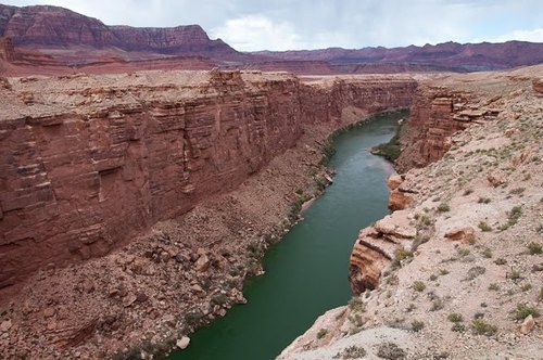
Another similar crack is the Rio Grande Gorge is one of them. 800 foot deep in New Mexico. If there is a water source it would flow inside it but
it doesn't mean that it was created by water flow.
In the north of Canada on Davon island is the Haughton impact crater shown on the radar image below. You see the cracks caused by the impact and the similarity with the Grand Canyon. You notice the relatively flat surface, the status the earth crust should have looked like before the impact. You notice the splitting of the earth crust due to the expansion after the impact: 75°51'36.01"N90°57'25.57"W W73°36'51.09"N94°13'4.24"
Below we see in Norway cracked earth crust.
Below for comparison is the San Andreas Fault which is a fracture or a crack in the earth crust, there is a similarity with the Grand Canyon which means that the Grand Canyon was formed in the same way.
The whole area around the mountain could be a part of the twin plant that landed or fall on the round surface of the earth and took its round shape which caused the crack in such a form. The upper layer of Sand Stone lays over the original Limestone bottom surface. Another possibility is that the huge parts of the twin planet when falling on the surface of the Earth caused such cracks. It could happen also due to the expansion of the earth crust.
Some scientists talk about great Unconformity of the Grand Canyon.
Read: http://written-in-stone-seen-through-my-lens.blogspot.com/2012/01/great-unconformity-of-grand-canyon-part.html
Above is the San Andreas Fault you notice the same cracks like the Grand Canyon.
Below you see the different types of rock meet along the San Andreas Fault. I think that the dark one to the right is of the impact bodies (granite or sand stone) and to the left is the original earth limestone crust. You notice the impact power uplifting the crust.
The next image is a space view of the Fault Line in the Andes, here you notice that it lays parallel to the granite mountains.
It is caused by the weight and pressure of these mountains.
On the moon we have fault lines; they emerged as the moon is shrinking. The cooling has reduced the radius of the Moon by around 100m in the relatively recent lunar past, evidence indicates. Which means that there have been geological events similar to those on earth but without plate tectonics.
I even think that the earth was in great danger as its core was cooling and the live was threatened but this impact caused a new heating of the earth inside by melting the core as a result. We must realize that all planets are cooling by time, the same happened to mars which was warmer and living but the cooling ended any life possibility. We have enough evidence now that there was in the past lots of volcanoes on Mars but now no more.
The collision may have added even water as the other planet had water too.
Fault systems are in the Himalayas and Tibet, and in California not far from granite mountain and not far from the ring of fire.
I think that the heavy Granite Mountains are causing earthquakes and volcanoes as they slide and bush deeper into the earth and that effect makes us think that it's the tectonic pressure or force. There is even the possibility that the twin planet was hit by a large granite space body but didn’t destroy it but it was nailed into it. The weight and pressure of that body caused volcanoes and earthquakes and cracks as it kept on pushing into the depths of that planet and caused the expansion of the crust till it exploded. Which means that the earthquakes and volcanoes could be caused by a similar pressure.
http://www.telegraph.co.uk/science/space/7954686/Surface-cracks-show-the-Moon-is-shrinking.html
Fault systems and the ring of fire are around the Himalayas and Tibet and California not far from the Granite Mountains, which according to my theory are pushing downwards and cause such formations.
Mars has the longest and deepest canyon system anywhere in the solar system. Valles Marineris extends for nearly 2,500 miles (4,000 kilometers), making it about nine times longer than Earth's Grand Canyon. But the reason was not flood waters once existed on that plant. It was probably the large meteorite impacts that hit the planet.
Is not an evidence for Martian plate tectonics. it is just a big crack. Mars has almost no thermal energy any more. We shouldn’t take fault lines as an explanation or reason for plate tectonics.
See Mars surface video:
http://www.youtube.com/watch?v=crsqzZNUXsY#t=203
http://www.youtube.com/watch?v=U5pnfpRiwi8
the granite mountains for me don’t look like been formed by tectonic pressure. According to the tectonic theory the movement was very slow it took millions of years to form, but the sharp edges of the Granite mountains look more like been formed very fast and violent, they look more like broken parts of a planet. According to my theory if the continents have moved thousands of kilometers which mean that there must be a relation or mathematical pattern between the height of the mountains and the distance that the continents or plates moved.
If Granite was pushed from the bottom to the top or uplifted, we would find uplifted parts of the surrounding rocks with the Granite. It's always pretended that such rocks have eroded away, but there can't be a total vanishing as predicted. The granite itself would have protected large parts of these rocks. It's also hard to imagine that weaker rocks and smaller in mass are able to push harder mass like granite to such heights.
If the continental plates movement caused the mountains to rise till they reached such heights, that means that the movement was converted from a horizontal movement to 90 a degrees vertical movement and on the same spot. Which means that the horizontal movement stopped? If the plate did keep pushing the mountain wouldn’t that change the angle of the mountain and cause it to collapse? If the plate is continuing to move it would form smaller mountains in parallel lines.
The continental plated haven’t been physically detected till now.
The granite mountains look very young, no great signs of erosion that should happen in millions of years, if they were really so old. They must be much younger on Earth than thought. The collision was probably in the last few hundreds of thousands years and not millions of years ago.
We don’t find granite boulders in the rock strata but just near the surface, which means it's not an ongoing process but just related to a certain date.
I believe that the original earth looked more like mars or mercury more flat having volcanoes and impact craters and covered with lot of water it was a kind of water planet. Changes happen in the universe, we even pray every time that the passing by asteroid is not going to hit us. The Granite Mountains on earth don’t fit in the geological scenery. The round shaped boulders everywhere couldn’t have been formed by moving with flood water or glaciers (glacial erratic) as we find them in places that never experienced an ice age, like Africa. An erratic is a rock that differs from the type of rock in the area in which the rock rests. Erratic rocks are carried by glacier ice often hundreds of miles from the rocks origin.it is a hypothesis that I don’t agree with. These boulders are smaller space bodies, parts of the impact. Many of them have crakes after hitting the earth. These crakes are not caused by a horizontal force. Then we have the so called Granite domes or the Inselbergs or Monadnocks found worldwide. Many such domes are found in the USA but also elsewhere. Like the Granite dome in the Yosemite national park in California, The Half Dome in Mariposa County, California or the enchanted rock in Texas or in Brazil the Corcovado Mountain in central Rio de Janeiro and in central Africa. These domes look more like large size boulders, they are just different names for different sizes of boulders, the size doesn’t matter. they could be a part of the surface of the twin planet.
The images I am showing later are going to show you my point of view.
About the Granite it is thought that it was formed from lava is for me not the right explanation.
It is thought that granite like basalt are formed of hardened lava. Basalt is formed from Lava; we see new formation of Basalt in Iceland and on the ocean floor, but no any indication of new formation of Granite.
The two rocks have different chemical composition.
Basalt is an igneous (volcanic) rock formed from the rapid cooling of basaltic lava exposed at or very near the surface of a planet or moon. basalt is an aphanitic igneous rock with less than 20% quartz and less than 10% feldspathoid by volume it is composed of calcic plagioclase (usually labradorite), clinopyroxene (augite) and iron ore (titaniferous magnetite). Basalt may also contain olivine, quartz, hornblende, nepheline, orthopyroxene, etc. Basalt is a volcanic equivalent of gabbro.
Black color is given to basalt by pyroxene and magnetite. Both of them contain iron and this is the reason why they are black.
Granite is an igneous rock consist of feldspar, quartz, mica, and amphibole minerals with at least 20% quartz and up to 65% alkali feldspar by volume.
This mineral composition usually gives granite a red, pink, gray or white.
We notice the different chemical composition and that makes the difference and not the slow cooling of granite.
basalts forms the most of the ocean floor, most large oceanic islands, and continental flood basalts such as the Columbia River Plateau.
basaltic rocks (including gabbro, diabase and their metamorphosed equivalents) are the most common rocks in the crust.
Basalt is also common on the Moon and other rocky planets of the Solar System
Basalt is one of the most common rock types in the world. Basalt is the rock most typical of large igneous provinces. The largest occurrences of basalt are in the ocean floor that is almost completely made up by basalt. Above sea level basalt is common in hotspot islands and around volcanic arcs, especially those on thin crust. However, the largest volumes of basalt on land correspond to continental flood basalts.
Basalt is the original constituent of the crust from which almost all other rock types have evolved. Basalt forms when mantle rocks (peridotite) start to melt
I think that the difference is not only the slow cooling but total different physics. Granite is an extraterrestrial product, most probably belongs to a different solar system.
Below is a photo of Salisbury Crags in Edinburgh is basaltic sill (a tabular sheet intrusion). Here it clear that it was uplifted due to an impact the same way like the other uplifted rocks, but we never find a similar form like in the case of Granite Mountains also the presence of basalt is huge and it should be uplifted as thought in the case of granite with the same heights.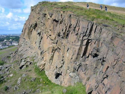
Now we have some forms of granite bodies:
Below is a broken granite boulder called the Split apple rock in Motueka, South Island, New Zealand, were you see obviously that the cause is striking the earth surface. You find thousands of such examples all over the globe. Such formations haven't anything to do with plate tectonics.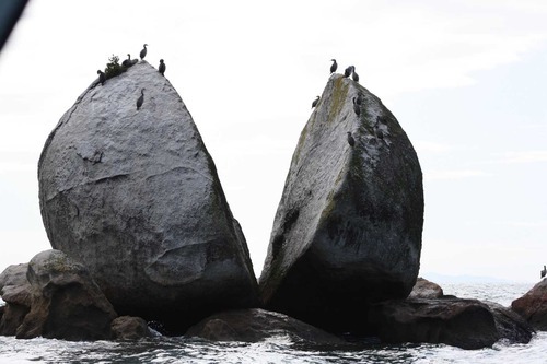
Below is a broken granite boulder called the Split apple rock in Motueka, South Island, New Zealand, were you see obviously that the cause is striking the earth surface. You find thousands of such examples all over the globe. Such formations haven't anything to do with plate tectonics.
Above is the Clach Bharraig is a large boulder perched on the hillside above the road to the car park at the Cairngorm ski area.
Above is the Las Vegas, Red Rock Canyon split Rock. Only an impact could cause such a split.
Below two images of huge boulders from the Yellowstone National Park in the state of Wyoming U.S. You see that the first one has a crack.
Below a is huge boulder in New England on the south shore is split all the way through.
The next image is a split rock in Newman Sound in Canada. Thought to be a Glacial Erratic but it wouldn’t cause such a crack.
Above is the Nose Creek Pathway Erratic in Calgary West Nose Creek Park, also known as Confluence Park Canada.
Below is another cracked granite boulder in Scotland Ffionphort.
Below another split rock at Mount Woodson area in the northeast corner of the city of Poway north of San Diego and just south of Ramona. Here another evidence for a crack that could only be caused by an impact.
The next image is the Tilden canyon shattered rock at Yosemite National Park. Such a damage can only be done by an impact.
Below the granite split boulder and sits on top of Steamboat Rock in Washington.
The Enchanted Rock or the Llano Uplift seen below 15 miles north of Fredricksburg in central Texas is a roughly circular geological Granite rock (considered as a Precambrian rock) rises 122 m. above the surrounding landscape surrounded by boulders an evidence of the impact and fallen rocks.
The rocks are even on the top of the dome, another indication that it fall on it. Such scattered boulders are everywhere not far from the Granite mountains. They could have got their shape when entering the earth atmosphere. You can notice that the upper part was separated as an egg shell according to the heat when entering the earth atmosphere and the collision with the earth.
As you see below the boulder broke as a result of the impact.
Below you see the Stone Mountain in Atlanta is a mysterious rock almost round and solid piece of granite. On the top of it are marks like carvings could be man made not by ice as mostly thought.
Below a similar stone mountain in Georgia.
Below is Australia's largest exposed granite rock Bald Rock is and second largest rock in Australia and is the main feature of the Park. This magnificent dome is 750m long and 500m wide.
Below in australia queensland girraween. The granite at Girraween is just one small section of a great mass of rock - the Stanthorpe Granite - which underlies most of the Granite Belt of Queensland part of the New England Batholith - which stretches from just south of Warwick (in Queensland) down to Armidale (in New South Wales); a distance of just over 250 kilometres (160 miles). You notice the similarity with the Llano Uplift above.
The next image from Australia the Granite Arch in Girraween National Park.
The next image from New Zealand, the Punakitere Sandstone boulder.
Above is a Granite dome at the Yosemite national park in California.
The photo below shows one of many huge boulders thought to have fallen off the Yosemite dome. This can happen just in case that the Yosemite dome itself fall on the earth and parts broke off due to the impact.
Above is the Old Woman rock formation (Joshua Tree National Park)
Below is a cracked boulder in the Bradshaw Mountains in central Arizona.
Below in Hon Kong the stone pillar of the village, Shek Shun Cheun, the great menhir Island Fan Lau.
Below is the summit of Crungie Clach near Pitlochry, Perth and Kinross, United Kingdom (619m), thought to be a granite erratic but the ice would move it down the hill and not to the top.
Below is the Split Rock, located just outside the village of Easkey is a large glacial erraticin County Sligo, Ireland.
Below in Nigeria the Amoye Inselbergs (Olosonta Hill) - in Ikere Ekiti
Below is another granite dome in India Lyngam- West Khasi Hills.
Above is the Corcovado Mountain in Rio de Janeiro, Brazil.
Above are the maps of North and South America, you notice the granite mountains to the west and below the map of Asia showing the Granite mountains in central Asia. These are the biggest parts that hit the earth (main impact bodies) which caused the expansion of the earth crust. But there are other smaller parts that hit different parts of the globe. some islands have been formed of such extraterrestrial rocks.
Below is a map showing the Structure of the Sierra Nevada.
You see the large granite body that struck the area and a lot of smaller ones.
Above is a satellite image of the Brandberg Granite Mountain in Namibia clearly seen the dark circle around the mountain caused by the heat of the impact. You notice as well the two dark spots to the right were magma or lava came of it from inside the earth after the impact.
Another evidence for the impact is the Verdefort crater in the Transvall Basin in South Africa, seen in the image below, the largest impact crater on Earth almost 300 km in diameter. It consists of a granite dome 40 km in diameter in the center of the crater. Then we have different kinds of rocks forming rings round the crater center like an arc of Ventersdorp lavas formed by the lava flowing out of Earth after the impact and then we have the outer rings formed mainly by Ghaap Dolomite rocks a form of carbonate mineral like Limestone which belongs to the original Earth before the impact. We find high content of iridium in the area which is mostly found in meteorites . We find also platinum what I think that it has extraterrestrial origin and wasn’t formed on Earth, the same could be the case with gold and the whole platinum-group metals.
Also the Tswaing crater below in South Africa is a smaller one (1.15 km diameter) it has enough granite remains to be a prove that this meteorite was composed from granite. It's also an evidence for the existence of stony meteorites impacts and not only iron meteorites. The surrounding area known as the Bushveld complex is one of the important sources of the platinum group metals. The crate floor is covered with a high concentrated saline lake, what could be an indication that the salt on earth could have an extraterrestrial origin.
http://www.lpi.usra.edu/science/kring/epo_web/impact_cratering/enviropages/Tswaing/Tswainggeologypage.htm
Below is the Araguainha crater in Brazil which has a granite central core.
The Tenoumer crater in the western Sahara is another evidence for the abundance of granite in impact craters.
The Atacama crater in northern Chile South America has a granite.
bedrock. The granite inside the crater reveales a reverse magnetic field
Polarity. The issue of reverse polarity is noticed mainly in Granite and not Basalt.
The outside rim of the Pingualuit Meteorite Crater is covered with a jumbled heap of large fragments of granite blocks. These could be remains of the impact body that was destroyed. The melt rocks are recognized as a mix of granitic gneisses rocks.
Below is the Ayers Rock or Red Rock, in the Ayers Rock in Uluru National Park in Australia, you notice the dark circle around the mountain caused by the heat of the impact. The Uluru rises to a height of about 340 metres (1,114 feet) above the desert plain, its summit 867 metres (2,845 feet) above sea level. An isolated sand stone rock-mass, it measures nine kilometres (5.6 miles) around its base. It consists of many layers, it looks like been uplifted standing almost vertical (dipping at 80–85°).
Not far from the Ayers Rock you find the Kata Tjuta rock. Kata Tjuta is about 30 kilometres (18 miles) west of Uluru, consists of a series of huge, rounded rocky domes as seen below. It reaches 1069 metres (3,507 feet) above sea level and about 600 metres (1,970 feet) above the desert floor. these spectacular domed rock-masses cover an area of about eight kilometres (five miles) by five kilometres (three miles). The rock layers here only dip at angles of 10–18° to the southwest,
35 kilometres (22 miles) north-west of Kata Tjuta you find pebbles, cobbles, and boulders of other rocks and consist mainly of granite and basalt, but some sandstone, rhyolite (a volcanic rock), and several kinds of metamorphic rocks are also present.
Below from the same area you see the boulders that fall on the domes.
The geological origin of these rocks is still confusing the geologists. There are many illogic theories.
Read more: https://answersingenesis.org/geology/natural-features/uluru-and-kata-tjuta-a-testimony-to-the-flood/
These sand stone formations don't seem to belong to that place, the look extraterrestrial.
According to my theory these might be middle size parts of the twin planet that hit that part of Australia.
If we move to the south of Australia we find the Nullarbor Plain
the world’s largest single piece of limestone, covering an area of 270,000 square km and extending some 1,000 km from the east to the west.
The Nullarbor Plain ends at the spectacular Bunda Cliffs, comprising a 200-kilometer-long precipice curving around the Great Australian Bight.
Located on the Great Australian Bight as seen below.
It consists of Wilson Bluff Limestone a chalky material formed as part of
an ancient seabed before being uplifted. Its the same like in Antarctica, as both have been separated by the impact. The Wilson Limestone is up to 300 metres thick. The cliffs are 60 to 120 meters high.See more: http://www.amusingplanet.com/2013/05/bunda-cliffs-in-australia-is-this-end.html
I believe that its a part of the crust of the original earth before the collision.
You are not going to find any trace of sand, no one grain. The sand didn't exist on the planet originally. If there have been sand in the sea like now we would found it mixed in the rock. Where was the sand in that time? It existed on the other planet. Interestingly we find almost the same formation in the north of the globe. In England in Beachy Head seen below.
Therefor I think that the orignal earth crust consised mainly of lime stone. The granite and sand stone belonged to the twin planet.Above is the so called painted rock which seems not to belong to the area, underneath is a kind of cave with old paintings and symbols of unknown origin. You can notice that some rocks broke apart after the impact and they lay nearby.
I imagine that the twin planet was a smaller planet, had a lower gravity and was inhabited by different species, like dinosaurs and a kind of human race and huge trees as well. After being hit and destroyed to smaller parts it moved towards the earth and was captured by the earth gravity until the collided together. The dinosaurs and the bigger trees went extinct and some remains petrified. Some of the smaller species survived. Could this be possible? The scenario could be as follows: The impact pushed the planet towards the earth it didn’t have the same speed like asteroids as it didn’t travel a long distance in space, it depended on the earth gravity, the bigger parts took probably a spiral orbit and landed on different parts on earth which were covered by bigger oceans, smaller parts fall in the form of boulders with higher speed and bombarded many parts on earth. The theory of the Yucatan impact crater could be real, but it was only one of many others. The middle size parts formed smaller mountains and islands.
Granite mountains photos: http://www.panoramio.com/user/3240777/tags/Granite%20Mountains
Another evidence of the impact is Scientists have found compelling evidence that a meteorite storm hit the earth more than 12,000 years ago, and is likely to have been responsible for the extinction of a prehistoric people and giant animals including mammoths.
Read more: http://www.dailymail.co.uk/sciencetech/article-2158054/Scientists-discover-evidence-meteorite-storm-hit-Earth-13-000-years-ago-killed-prehistoric-civilisation.html#ixzz2q4rkAMYd
Below are Chinese astronomers inspect a big stony-iron meteorite that was found in Altay prefecture, Xinjiang Uygur autonomous region, on July 17, 2011. The above-earth part of the rock is 2.2 meters long and 1.25 meters tall. The location of the meteorite shows that it fall with the rest of the boulders as it didn't cause any damage to the other boulders.
Read more: http://www.whatsonxiamen.com/news20233.html
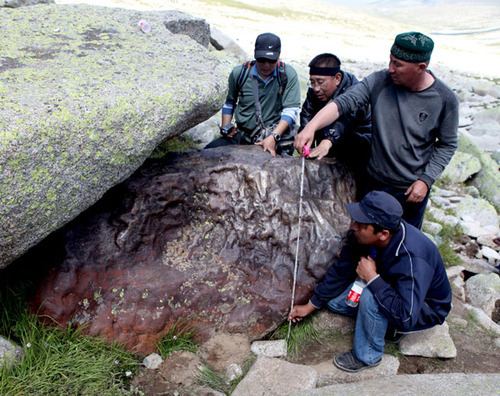
This meteorite is found among other granite boulders or meteorites. Which is a rare case but is evidence that these granite bodies when they were in space they pulled the iron meteorite while falling on earth. It means at least that the existence of the granite boulder on earth is younger than the iron meteorite.
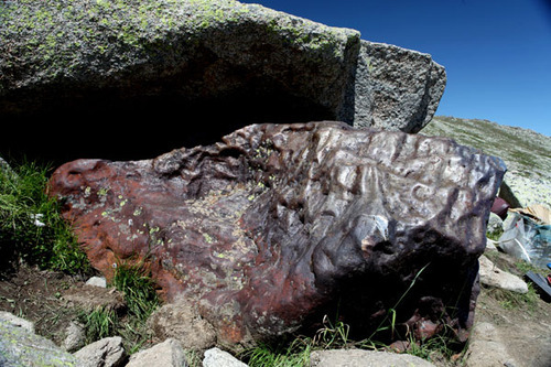
I would say that after the planet explosion there was a kind of asteroid belt orbiting the earth similar to the asteroid belt located roughly between the orbits of the planets Mars and Jupiter.
This meteorite is found among other granite boulders or meteorites. Which is a rare case but is evidence that these granite bodies when they were in space they pulled the iron meteorite while falling on earth. It means at least that the existence of the granite boulder on earth is younger than the iron meteorite.
I would say that after the planet explosion there was a kind of asteroid belt orbiting the earth similar to the asteroid belt located roughly between the orbits of the planets Mars and Jupiter.
But what could have happened to the twin planet if it was inhabited?
Did the inhabitants of the twin planet know that a cosmic catastrophe is on the way?
Was the destruction of the planet caused by an impact or a disaster caused by the inhabitants themselves? Did it collide with the earth due to the gravity of the earth (being captured by earth gravity)? Was it hit by an asteroid or its own moon that destroyed it and pushed it towards the earth? Was it another moon?
Did the inhabitants of the earth notice that a planet left its course and is moving towards them? Did the inhabitants of the twin planet build structures to protect them when entering the earth atmosphere? I think we would have done it.
The twin planet could have been a moon that circled the earth. Which means that the collision wasn’t the destructive like being hit by a fast moving body like an asteroid or a meteorite. The twin planet could have been hit by a moving space body that crashed it and bushed it towards the earth.
Stories about Atlantis and aliens visiting the earth:
https://bruceleeeowe.wordpress.com/category/conspiracy
http://www.virtuescience.com/grooved-spheres.html
http://davidpratt.info/andes1.htm
Evidence of extraterrestrial civilization on the twin planet:
Petroglyphs, Monolithic structures, Dolmens, Menhirs and strange looking features
We notice the kind of metallic patina or coating of the petroglyph rocks and also in the megalithic structures in Peru. There is a similarity between them. They are not a result of erosion.
A scientist that did detect a kind of vitrification was late prof. Watkins. He said that the rock surfaces on Inca stones are similar to those that have been thermally disaggregated. Indeed, some of the slick surfaces on the Inca building stones are glazed, so it becomes apparent that the Incas must have used thermal disaggregation..
http://blog.world-mysteries.com/science/evidence-of-vitrified-stonework-in-the-inca-vestiges-of-peru
http://www.pbase.com/manco/image/21583800
Evidence of Vitrified Stonework in the Inca Vestiges of Peru.
http://www.ancient-mysteries-explained.com/support-files/evidence_of_vitrified_stonework_in_the_inca_vestiges_of_peru.pdf
http://secretsofthesunsects.wordpress.com/2011/12/05/incan-vitrified-stones
http://www.grahamhancock.com/forum/JongJP1.php
Alfredo Gamarra's investigations and theory are based. He came to the conclusion that the 3 different styles we recognize in all the vestiges, correspond to three different periods of human history. The first style is holy for the two later styles. The vestiges of the first and second period show phenomena that till now where not explained in an acceptable way. Alfredo Gamarra said that, because of less gravity in the past, it was possible to handle huge blocks of stone, treat stone with moulds, and give them a vitrified finish. Those stones must have been soft once. But Alfredo Gamarra said that the perfect fitting blocks do so because they were moldable on the moment of construction. If Alfredo was right, one can imagine that especially bigger blocks were more difficult to treat, as the weight of the clay-like block would have given problems to keep them in place, and the clay could have had the tendency to deform. The clamps would have served for keeping the blocks together, so they would harden out in the right position. The observation that the groove has been polished is important here. The same can be observed on the borders of the stones of the perfect fitting walls. Some technology with heat was applied to give form and strength to the construction. This means the shine is not because of polishing, but would be vitrification. The relatively big presence of the first style in Cusco and surroundings, leads to the conclusion that this part of the world was important during the first period, and could be considered as the cradle of Humanity
1) petroglyphs:
I think that the petroglyphs have been done on those boulders or rocks before its destruction probably on the twin planet. The power of the impact was so strong that lots of these hard rocks (mostly Granite or hard sandstones) have suffered such a damage, as the cracks are seen on the most blocks. We notice that many petroglyph sites are not far from areas where petrified trees and
dinosaurs. Which made me think that there could be a connection between them. What caused the destruction of the rocks containing the petroglyphs and also the extinctions of the human race related to them could be the same reason of the extinction and petrification of the dinosaurs.
The petroglyphs are made on a flat surface which is clear that it was man made flat surface as we can notice the marks of some kind of tool. I am going to show you some photos were you can see the broken stones with missing parts of the petroglyphs and also the flat surface which wasn’t done by nature.
You find these rocks in places you don’t expect to find them, or you ask your self when you see them who brought them here.
You are going to notice all of them have the brown patina and all of them suffered a great damage and you feel that they are just a part of a bigger wall or structure which was full with such symbols. These engraved rocks are mostly found in total remote places where its hard to imagine that these places were once inhabited. And if you find some tribes that lived around you notice that there isn’t a real connection to the petroglyphs. These petroglyphs show a kind of stone masonry that these tribes didn’t possess. These rocks don’t look been accidently decorated by a passing byer. All over the world they are scattered and destroyed.
One of America's most interesting national parks is located in northeastern Arizona not far from the more well-known Grand Canyon. The 93,533 acres of Petrified Forest which contain America's largest deposits of petrified wood, a rich and colorful desert, many fossils of dinosaurs and other creatures, and more than 500 archaeological sites including amazing petroglyphs left by ancient cultures
http://www.shannontech.com/ParkVision/PetForest/PetForest.html
Above is the Greaser Petroglyph Site in Oregon
Above the so called Apache spirits southeastern Arizona and north-western Mexico, you notice the cracks the flat surface and the patina.
The patina could have been caused by the heat of the impact or the effect of the atmosphere on the twin planet.
Below a petroglyph from the Anasazi Valley. Looks like belonging to a bigger scene.
Above the so called Coso Shaman human like figures overlooking the Renegade Canyon on the China Lake CA.
The next petroglyph shows clearly the man made flat surface and the distraction of a bigger stone complex a kind of sacred mountain in Columbia Hills State Park. You notice to the top left a rock that appears to be a corner of a chamber.
Tamgaly is a World Heritage Sites in Kazakhstan one of the World Heritage Sites in Northern and Central Asia.
See the scale of destruction of the granite mountain; you see that the damage was after creating the petroglyphs. Another thing what you can see clearly is that the flat surface have been worked out by a tool, you can see clearly the marks of the tool. Another thing is the patina, it looks like glaze or painted. The lower part has been affected by rain or floods. The scenes are very similar to other places like the Americas or Australia.
Above is a Tamgaly petroglyphs in Kazakhstan notice the man made flat surface. The animals some could be dinosaurs. Notice the damage done by the impact. You can watch this site in this video: http://www.youtube.com/watch?v=tcWFwh0fBN4You
Above is the Tamgaly petroglyphs from the Semirechie region in Kazakhestan.
Above From tamgaly petroglyphs Kazakhstan clear evidence that the petroglyphs have been a part of a mountain and not some scattered boulders.
A Tamgaly petroglyphs above in Kazakhstan shows clearly that it’s a broken part of a bigger scene or inscripted structure. Here you see the broken parts and the original colour of the rock and also the same patina or glaze coating similar to other places and even found on some walls of constructions in Peru, like the image below. It was believed that it was polished, but now there are some studies that it could be a kind of metallic coating or due to high temperature.
Below a petroglyph rock from Kyrgyzstan.
Above other broken parts Petroglyphs nearby the river Koksu in
Almaty Province, Kazakhstan.
Below a Prehistoric rock carving of deer. Bayankhongor, Mongolia
Below a Oregon Petroglyphs, you notice the damage and also the unnatural surface with the metallic glaze patina.
Above is a flat man made wall with petroglyphs at Deep Canyon Bishop.
Below is the Molen Reef Petroglyphs in Utah. Here you notice that the patina is only on the front side and not on the broken side on the left, which means that the patina is older than the damage of the stone as if it was the weathering that caused the patina it would have been on the whole rock. You notice too that the petroglyph is on a flat surface.
The next one is the Newspaper Rock State Historical Park in Utah. Here it's clear that only the surface that have been engraved is tainted in compare with the rest of the rock. And here it’s the normal position as a kind of monument and not as a damaged rock on the ground.
The next petroglyph is from the lobo-canyon in the Cebolla wilderness in New-Mexico. You see the flat surface and the broken part don’t have the patina..
Above the so called Eagles Nest in Jubbah Saudi Arabia, the same flat surface.
Next petroglyph is in Greenwater Canyon as you see at the top left the original level of the rock and beneath parts have been removed to make the flat surface.
The next petroglyph is from the Rabbit Site. The man made flat surface is clear, also the sign that a tool was used.
Above Rock art at coso range eastern California it seems it was a part of a mountain, but what caused this huge damage which is a pattern in other places far away from each other.
The Petroglyphs below from the Petrified Forest National Park, Arizona.
The block above looks more like a building block.
Above is a Petroglyph in the Petrified Forest National Park, in northeastern Arizona, you see clear signs of damage, the flat surface is man made and clear that it was a part of a bigger construction. Did these rocks fall from the heaven?
Below is the Grapevine Canyon its located in the very southern tip of Nevada below what did such a damage?
Below is a Hopi Rock Art Petroglyph in Navajo Reservation in Arizona
Below a petroglyph in the Anasazi Valley in Utah. Lot of scattered damaged rocks that don’t belong to the geological formation of the area. These rocks look like have been part of one solid structure.
Below a petroglyph in Oregon, you notice the crack.
Below from the Sonoran Desert National Monument Arizona. Another cracked rock.
The Checta Petroglyph IN Peru. The word Checta means ‘broken rock or cracked firewood’ in Quechua, an ancient language still spoken in some parts of the highlands of Peru. The Checta Petroglyphs, discovered in 1925 by the priest Pedro Villar Cordova, are composed of almost 100 rocks, depicting approximately 450 carved images which resemble humans, animals, plants, celestial bodies and other drawings with abstract characters of difficult identification. Most of the petroglyphs face north and northwest.
They are scattered in an archaeological area of about 8000 square meters in Querena Hill at the confluence of Alcaparrosa Ravine with the left bank of Chillon River Valley at approximately 1200m in the District of Santa Rosa de Quives, Province of Canta, Department of Lima, in Peru.
The age of The Checta petroglyphs is uncertain. see image below
Below from French Guiana, Suriname. Stones with petroglyphs showing signs of destruction. You see the patina as elsewhere.
http://www.youtube.com/watch?v=HeyjEM90l1w
Above is the Pilbara area of Western Australia you find such petroglyphs, the same rocks all over the globe, all of uncertain origin or age.
Australia’s thought to be ancient Aboriginal engravings of human-like figures, animals and diverse human faces can be found in the Burrup Peninsula and surrounding Dampier Archipelago
Below from the Acacus Mountains are a range of mountains in the extreme south west corner of Libya in the Sahara.
2) Megalithic structures:
Such structures are found in different places especially in South America and Asia. They are built of silicon based rocks.
Inca construction below is built on the top of a mountain almost unreachable, it's a bigger part of the destroyed planet.
Below is a bird's eye view of Machu Picchu in Peru.
Sacsayhuamán ruins in Cuzco, Peru you notice the similarity with the boulders carrying the petroglyphs
.
Different usage and philosophy comparing the upper part with the older lower part. You notice the Newer buildings on the top of the old once.
Above the Ollantaytambo monuments in Peru , the upper part of the rock monument is destroyed, what did it? And where are the remain.
Above in Machu-Picchu in Peru the lower monolithic part is from an older structure turned upside down and you notice the tool marks on the stone. Newer buildings have been added. I think that the structures in Peru have been built on three different stages. The lower part is carved in the rock and impossible to be done in our world, on the top of it are buildings using huge blocks also of sophisticated technology and then buildings using smaller blocks, looks like trying the reconstruct older structure. The last stage could have been done on earth using older stones after been cut in smaller parts, as the low of gravity changed.
The next image is a part of an older construction which stood probably on its original location in vertical position or was a part of a façade and have been used later as a fountain but the missing parts of such structures will never be find.
The next image is from Qenko in the Sacred Valley of Peru located in the Cusco Region, Cusco Province. It has a similarity with the Rodadero Smaller-scale configured rocks in Peru include the Sayhuite monolith, a rock with more than 200 geometric and zoomorphic figures near the town of Abancay, and a carved rock at Concacha near Abancay. Similar rock-hewn structures elsewhere in the world include the carved stairs, platforms and caves at Udayagiri/Khandagiri, near Bhubaneswar in India, and the massive underwater monument off the coast of Yonaguni, the southernmost of the Japanese Ryukyu Islands. This kind of similarities should be taken in consideration. The similarity is not only in the structural form but also the kind of stone used, the perfection of the work and the unknown origin, function or age (estimated by the most as much older than thought to be) and also the destruction they suffered. The most of such structures are located on the top of mountains, very remote and due to its size and weight impossible to lift to such high locations. This observation is to be seen in different parts of the world. Specially the next image you see the cracks on the rock. These rocks don’t have the same geological formation like the ground beneath. Such work needs a very advanced technology. These kinds of structures are also impossible to imagine to be used by humans lived in such far ages with the absence of any other artifacts or tools or even any creatures which could be related to them, specially those in Machu Picchu, Cusco and Puma Punku. They are very abstract and timeless. I think they don’t match to the human mental development of the estimated age. The look more like done in the future and not the past.
See interesting information:
http://davidpratt.info/andes2.
See more pix http://peruenroute.wordpress.com/2012/01/06/sacsayhuaman-northern-zone-ii/
http://www.world-mysteries.com/mpl_9_vitrified_rocks.htm
The next is a video of the Colina Suchuna, a strange, vitrified rock at Sacsayhuaman, Cusco in Peru. See all the structures that were made in this rock, it looks as if they were pressed into the rock when the rock was soft once. The rock is so smooth that it is used as natural slides. It is considered an Hanan Pacha structure by Jesús Gamarra, also because it is surrounded by walls with perfect fitting stones from the Uran Pacha time. you notice the huge scale of destruction which coldnt be made by human force and there is no reason for. The only logic explanation is that it fall from space.
See more information:
http://www.youtube.com/watch?v=Ly7D_xD-fns
http://home.comcast.net/~georgesaunders/ancient.html
http://www.youtube.com/watch?v=ae_8ri2fiwI
Below a part of the structure built in the rocks turned upside down, obviously part of the twin planet. Below you see the scale of destruction in Machu Picchu. Such a form of destruction can only be explained as a result of a cosmic event as it lays on the top of a mountain like the most of similar cases.
Below is the Sayhuite monolith, the true purpose of Sayhuite is unknown. A rock with more than 200 geometric and zoomorphic figures near the town of Abancay in Peru. As if the structures have been made in softer rocks or clay and it was hardened or petrified after the impact, in the same way like the petrified bones, trees and ground with dinosaur footprints?
Read :
http://www.abovetopsecret.com/forum/thread940634/pg1%26mem=bigfatfurrytexan
A Sayhuite monolith below, The most amazing was a rock with carved stairways and ascending platforms which is cracked down the center. Clear evidence that it broke after hitting the Earth.
In the next video you see clearly the remains of a structure that have been totally destroyed and there are lots of missing parts, you notice that its on the top of a mountain, what indicates its falling from the sky.
http://www.youtube.com/watch?v=YLe5v3 8v2j0#t=359
The image above is the so called nine seats in Ñusta Hispana archaeological site in the Cusco region in Peru. You clearly see the boulder on the top right hand which means that the damage happened after the construction.
Below another rock that is broken from a bigger one but the other parts are missing.
Below is the Ollantaytambo Complex northwest of the city of Cusco in Peru. It is located at an altitude of 2,792 meters (9,160 feet) above sea level. You notice the highly sophisticated form and work that don’t match to the abilities of the tribes that lived in the area later, meant that the Inca are not the original builders. You find similar architectural elements of unknown origin and age all over the world, which means they belong to the same civilization. It is just beyond human known abilities. To have the knowledge and technology must have reflection in the daily life like artifacts, tools or even dress. The newly added parts could match but not the original old once. These parts look like been collected to be reused or considered as sacred ancestor's remains. You see that the next structure was partly removed from a bigger part as the bottom side is showing. The missing parts will never be found or they could have fallen on other parts of the globe or even buried under impact rubble.
You notice above that the structure on the top left hand is just a part of a building the rest is missing. You see windows and a door which means that it was a closed building. The teases and the steps don’t belong to the original structure they have been added later. I think that it stood more likely on a flat surface. This could be the explanation of how getting such stones so high. You see below how a similar structure originally looked like. You should imagine moving such blocks without damaging them even slightly by the edges.
Watch the next video; it’s a Google Earth 3D Model of Machu Picchu. Here you see that it's impossible to have had the same topography when building the original structure.
https://www.youtube.com/watch?v=YI6M9LC4Pn0
You see on the next image the technical ability of the followers. By comparing the walls and the size of stones used. You see how they used older big blocks on the top of the doors.
The next image are the remains of the Temple of the Sun. You see the fallen stones after the impact scattered on the ground. You see the perfect work by now mean comparable with the newer one.
The next image to show what I mean by original and new work.
It is the main gate to the sun temple in Ollantaytambo .in Peru
You see the original old gate and the newer added stones on the top and used in the back ground to reconstruct the walls
The next image is from Chavin in Peru were you notice that this block is just a part of a complex that have been severely damaged like the most similar remains of the so called lost civilization all over the world. You notice that newer parts have been added but complete different style and technology.
Another image below from Chavin showing the usage of some stones to build other ones where we notice that even the columns have different sizes. The answer is where the remains of all these perfect structures are and why couldn’t the followers using the same techniques to build the newer ones? We can compare these blocks with the others in the background.
Another picture from the same monument showing the worship of an older mysterious stone and the difference in the quality of work building the other walls. In this case I am not going to try to explain the meaning or function of the stone or what the image represent as it is almost impossible to use our logic which is for sure complete different than theirs, that is the matter with all these remains that belong to these so called lost civilizations taking in consideration the difficulty of dating of the original parts. But the question is how far were the two builders related? Sometimes I ask myself if they were done by human beings, or could dinosaurs have had the mental ability to achieve such structures? Was there a kind of coexistence between the both? Was that on the twin planet that hit the earth? I think it would be much easier to move such heavy stones under a lower gravity on another planet than under the same gravitational condition on our planet.
Another interesting place is the Chavin archaeological site in Peru; it was the capital of a pre-Incan culture, estimated to be ~4000 years old. What to be noticed is that the wall have been but together using stones that belonged to another structure and much older. A possibility is that the builders tried to reconstruct a structure that was heavily destroyed. You notice on the next image that heads have been put over each other. That could have happened 4000 years ago but the original structure was much older. I am even not sure if it was a structure or just a wall of a mountain.
The next image is from Guatemala from the mask temple of Lamanai that belongs to the Maya civilization. You have to notice that the temple have been added to the heads which belong to other damaged structure. The stones used to build the temple are smaller and show different workmanship than the heads. I think that the Mayans thought that they belonged to gods and constructed a temple around them.
Not far from the mask temple is the jaguar temple, in the next image you see parts with ornaments made from bigger stones and more complicated work have been added to rather simple structure built from smaller stones, which means that they are younger. Notable are features and the similarity with the Olmec heads.
The next image is of statues beside the Xia royal pyramid shaped tombs found near Yinchuan Ningxia province in Inner Mongolia in China. where you find feature similarities with other parts in the world. To be noticed that it is just parts of statues. These are 2 of 9 stone kneeling statues. The material and style don’t match with the tombs. It looks like have been collected and adopted in to the site. The site is a flat plateau surrounded by mountains. The statues don’t belong to the geological rock formation in the area. The building and tombs are made mainly from clay. Not using the same rock means that they don’t belong to the same structure.
Watch interesting videos:
https://www.youtube.com/watch?v=ae_8ri2fiwI
https://www.youtube.com/watch?v=x81-5SWVtUQ
See Top 10 Inca Ruins
http://travel.nationalgeographic.com/travel/peru/machu-picchu/inca-ruins-photos/#/huchuy-cusco_36197_600x450.jpg
We make a move to Asia where we notice a similar pattern of destruction which means that that event was a global one that hit the earth and wiped-out the existing civilization. The next image is thought to be a head of the Indian god Shiva at Unakoti. The head is 30 feet high without crown. The worshipers invented stories to explain the creation and destruction of these structures. The legend say that the god Shiva was going to Kashi with accompanied by other gods and goddesses, t hey made a night halt at this location. He asked all the gods and goddesses to wake up before sun rise and proceed for Kashi. It is said that in the morning, no one else except Shiva himself could get up so set out for Kashi , he cursed the others to become stone images, a naive legend just to explain the cause of destruction happened to these structures and not knowing the origin of them and its purpose. The destruction and the kind of stone is remarkable and shows a pattern of damage that is found in many parts of the globe.
Watch: http://www.youtube.com/watch?v=qwwGc6k2sxI
Below you have some monolithic structures found in Japan in the Asuka district, the purpose is completely unknown, the name is Wine-Ship-Stone very similar to those foundin Peru, even the same stone.
Above a carved granite stone the so called Masuda no iwafune found near the village of Asuka in Japan . 11 meters in length, 8 meters in width, and 4.7 meters In height. How or why this colossal stone and others was carved remains a mystery. They appear to be a different style than later Buddhist sculptures was found on top of a hill. Nearby the tomb of Ishibutai Kofun which is built from massive boulders including one that weighs an estimated 75 tons, but this tomb was built by using stones from other structure and shows no special technology like in the case of the called Masuda no iwafune which is a perfect work and of unknown purpose.
Below The Oni-no-Manaita Stone (The Devil’s Chopping Board) is on a small hillside to the east of the Mausoleum of Emperor Kinmei. An enormous granite rock of approximately length 4m, width 2m, and thickness 1m,
The geological map above shows the granite spots, the most of the old sacred stones lay on hills positioned on these spots.
An incredible discovery that was recently made in Russia threatens to shatter conventional theories about the history of the planet. On Mount Shoriya in southern Siberia, researchers have found an absolutely massive wall of granite stones.
Some of these gigantic granite stones are estimated to weigh more than 3,000 tons, and as you will see below, many of them were cut with flat surfaces, right angles, and sharp corners.
Nothing of this magnitude has ever been discovered before. The largest stone found at the megalithic ruins at Baalbek, Lebanon is less than 1,500 tons.
-
The next one is called the Russian-Stonehenge-Megalith-huge-block mysterious stones are found on the Mountain Shoriya in the Kemerov region of Russia.
See more at: http://humansarefree.com/2014/03/megalithic-site-discovered-in-russia.html#sthash.xwHl4YGG.dpuf
The next t image from Russia Pedan (Pidan) Mountain, Primorsky - wall-corner
3) Signs of great destruction to structures that stood on the twin planet:
I noticed that this destruction is world wide and caused by a huge force and it must have happened by the same event.
Most of the monolithic structures show signs of destruction and missing parts, the same is noticed on the stones carrying petroglyphs that they were parts of bigger structures. In the case of Egyptology when finding such stones, the first thing to do is to look for missing parts and try to put them together. But in the case of such an impact lots of those stones fall scattered on different parts and some are buried under bigger rocks. What is to noticed is that the most such structures lay on higher places and mostly on the surface and not buried deep in the ground. But we must imagine the size of the missing structures compared with the little remaining parts, or how it looked like when it was comlete.
Above the Büyük Kapı Kaya Turkey a part of a damaged granite structure in a place formed of limestone of unknown origin or age, probably a part of the twin planet.
Below two images also from Turkey in Afyonkarahisar-ihsaniye. It's one of the best examples for the damage done by the impact. You see the cracked rock with the damaged parts and you see the fallen one. You see that the damage was not in one place it was the same all over the globe. Such a crack can be only caused by hitting the ground or that the earth was hit violently.
Below another part of a structure in the Midas Monument in Central Anatolia Region, Turkey. The rest of the structure is missing.
Remains from the same structure, you notice that it was a part of a mountain and not a building. Remains of the patina like in other places and also the same flat surface like in the case of the remains with the petroglyphs in the Americas. You notice that they are turned upside dowen.
On the rocks above you see the man made flat surfaces; it's from the same area.
Above the Baalbek Stone in Bekaa Valley in Lebanon huge granite block unknown origin or purpose, no other parts found (no sign that it was a part of a structure). What could be noticed is the crack to the right exactly in the place between the part under the ground surface and the part above the ground; this happened when this part hit the earth and broke.
Above is the Yurak Rumi the sacred white rock shrine in Peru. It looks like have been brocken from a bigger part but were is the other part or parts?It looks like it could be moved but the huge size makes it impossible. Its another clear evidence that this is one of many parts that it belonged to the twin planet and fall on Earth after been destroyed.
Below in Seri Lanca all the same thrones and grounds (there are also more of them) had been cut from the whole, unbroken body of huge granite boulders. We see the similarity with the Yurak Rumi above. they look like parts belonging to the same structure but fell on two different parts of the globe.
Below clear impact cracks in Qenko in Peru.
The next images show The Gate of the Sun in bolivia before restauration and after. We notice clearly the crack caused by the impact.
Below is an another example from the same site.
Below is the Udayagiri and Khandagiri Caves are manmade caves of archaeological, historical and religious importance near the city of Bhubaneswar in Odisha, India. Notice Similarity with Peru. But the whole is a part of older unknown structure which was badly damaged.
The cave above is carved in the giant head which is much older.
Remains of the surface of the twin planet and of the civilization that existed on the Earth before the collision:
In the next part I am showing visual evidence in photos in videos where its clear that some of these monuments are parts of a planets crust with evidence of extraterrestrial civilization. These parts are now plateaus with missing parts. What we see in south America on the top of the mountains is not the original geography, these ruins were standing on rather flat surface of the twin planet, but when the twin plant was destroyed these parts formed mountains on our earth but they formed smaller plateaus. Some parts were turned upside down therefore there are missing parts which disappeared under the mountains. The geology and topography of the Earth changed totally. The Earth turned from rather flat and watery planet to a planet with irregular mountain surface. Some of the images are from the original earth which had its own civilization. These are the parts found on flat lime stone plateaus like in china and in the west of Peru as the satellite images are going to show. Below at the Pueblo Bonito Chaco canyon a clear evidence that the impact event happened after building the structure, a part have been damaged and huge rocks even fall inside the structure. You notice on the other image that a part of the plateau was uplifted and the rocks fall after the uplifting.
A place were I find a combination geological mystery and remains of a lost unidentified civilization is the Fajada Butte in Chaco Culture National Historical Park in northwest in New Mexico. It rises 135 meters above the canyon floor. Although there is no water source on the butte, there are some ruins of unknown purpose in the higher regions of the butte. Remains of a 95-meter-high, 230-meter-long ramp have been found on the southwestern face of the butte as seen below.
El Fuerte de Samaipata is a unique archaeological site in the mountains of central Bolivia, the caving is on the top of a mountain it seems to be a part of a bigger missing structure.
Above in Cusco in Peru unexplained stone another evidence that it was the surface of another planet, otherwise where are the missing parts of that structure.
A video showing Sacsayhaman in Peru from the air were you notice clearly that it was just a part of a bigger planets surface, where you notice clearly that there are missing parts:
http://www.youtube.com/watch?v=QVSmX1OVtlw
Machu Picchu from the air:
http://www.youtube.com/watch?v=PIZqBQ_R0LU
You find similar unexplained structures in Japan structures, same stones like Peru and unexplained damage.
Below is Sacsayhuaman, Cuzco in Peru
Below thought to be Anasazi Ruins, Chimney Rock Archaelogical Area. You notice the similarity with other ruins built on the top of a flat sand stone mountain. Looks like a part of once bigger plateaue. 37°11'30.26"N107°18'23.32"W
Below is a Nuraghi near Arzachena (Northern Sardinian Nuraghes, Southern Sardinian Nuraxis .The function is unclear some say a worship place some say a fortress others say rulers residence. They are found on top of hills. Its origin and age is unclear thought to be about 1,500 B.C. many say they are much older.
Above is a circular structure in the Aran Islands Landscape in Ireland. Built on the edge of a plateau, it seems that the second half is missing. It could be an uplifted part of a plateau.
Above is the city of Hattusa, in central Anatolia, is thought that the last-known Hittite king, Suppiluliuma II 1207 B.C. built it. There is not enough evidence about that. It was destroyed and abandoned sayed by fire, but the real reason isn’t known. According to my theory it was destroyed by the impact. It has the same features like a lot of sights that suffered the same fate. It lies on a flat uplifted plateau. Impact bodies or rocks that struck the site are visible. Hattusas was not the only city to be destroyed by fire at this time, as other cities of Central Anatolia appeared to have met the same fate: Alaça Hoyuk, some 25 Km to the North, also perished in a fiery catastrophe; Hittite palaces at Masat and Fraktin, as well as the fortified citadel of Karaogan, near present day Ankara, were also burnt to the ground in catastrophic fires.what is confusing me about this city is that there are two different construction types, one very monolithic and similar to the once in Peru shown in the next image and the other is a very simple one. Therefore I think that the city which have been destroyed was not the Hittite city but the original one or both have been destroyed but not the same event. There have been found large number of perfectly circular drill-holes cut deep into the granite rock as if by a tube drill. There you find the evidence of the presence of two different civilizations. below is the upper Hattusa city, I think that originally both were on the same level. You have then an imaginary reconstruction of the city which look like other circular cities that belonged to the lost civilization. You have two images showing the similarity with the Inca structures, the second one has reliefs on it but it is clear that these images don’t belong to the same structure. They are primitive to be compared to the elegancy and harmony and simplicity of the monoliths. The proportions are rude. Normally the whole wall would be decorated and not only a part. Here there is an attempt to imitate the Egyptian style.
On the first image you see both cities the upper and the lower Hattusa. You notice that the impact affected the ground with the construction on it. The builders would have leveled the ground before building such a complex structure. You see also on the aerial views below the deformation of the surface.
Above you have clear evidence that the site have been hit by fallen boulders. This kind of destruction is a pattern noticed in all prehistoric lost civilization.
The next footage is the Chankillo ruins, near the Peruvian coast
Some remains are easier to find as they are in desserts and have been protected by dry weather but some lay in tropical regions and have been damaged by floods and rain or hidden under jungle plants, other suffered from human activities.
Lots of lost cities are thought to exict and are hidden and undiscovered in different parts of the world. We have the Palenque in Mexico, the ruins in the Llanganates National Park in Ecuador, some discoveries have been made in the Amazon Basin and the Angkor in cambodia.Like the recently discovered remains of a major archaeological site deep in the jungle mountains in Colombia known as Cuidad Perdida (the lost city) in the Sierra Nevada de Santa Marta. As shown below:
Another newly discovered city is Tak'alik Ab'aj, it is a pre-Columbian archaeological site in Guatemala.
Angkor Wat below is one of the newly discovered lost cities.
Above is the Devils Tower it is located in northeastern Wyoming, USA.
Below is a strange formation in Urup Island Russia.
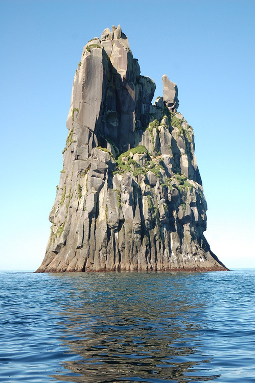
Below a rock formation a kind of waffle rock at Rocktown on pigeon mountain.
Below is a Carpet rocks
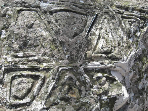